Cuba River Water Chemistry Reveals Rapid Chemical Weathering Promise of More Sustainable Agriculture
Published on by Trudi Schifter, CEO and Founder AquaSPE in Case Studies
Abstract
For the first time in more than half a century, a joint Cuban/American science team has worked together to quantify the impacts of chemical weathering and sustainable agriculture on river water quality in Cuba—the largest and most populous Caribbean island. Such data are critical as the world strives to meet sustainable development goals and for understanding rates of landscape change in the tropics, an understudied region. To characterize the landscape, we collected and analyzed water samples from 25 rivers in central Cuba where upstream land use varies from forested to agricultural.

Cuban river waters bear the fingerprint of the diverse rock types underlying the island, and many carry exceptionally high dissolved loads. Chemical denudation rates are mostly among the top 25% globally and are similar to those measured in other Caribbean islands. High rates of solute export and the distinct composition of the waters in specific basins suggest flow paths that bring river source waters into contact with fresh, weatherable rock—unusual in a warm, wet, tropical climate where weathering should extend deep below the surface. Tectonically driven uplift likely maintains the supply of weatherable material, leading to channel incision and, thus, to the exposure of bedrock in many river channels.
Despite centuries of agriculture, the impact on these rivers’ biogeochemistry is limited. Although river water in many central Cuban rivers has high levels of E. coli bacteria, likely sourced from livestock, concentrations of dissolved nitrogen are far lower than other areas where intensive agriculture is practiced, such as the Mississippi River Basin. This suggests the benefits of Cuba’s shift to conservation agriculture after 1990 and provides a model for more sustainable agriculture worldwide.
Manuscript received 17 July 2019. Revised manuscript received 17 Dec. 2019. Manuscript accepted 20 Dec. 2019. Posted 30 Jan. 2020.
© The Geological Society of America, 2020. CC-BY-NC.
https://doi.org/10.1130/GSATG419A.1
Table of Contents
- Introduction
- Background and Methods
- Results
- Discussion/Interpretation
- Implications
- Acknowledgments
- References Cited
Introduction
The Republic of Cuba (Fig. 1) has more than 11 million inhabitants, but there has been little collaboration between U.S. and Cuban scientists for more than half a century although only 160 km separates the two countries (Feder, 2018). River biogeochemistry data, which are sparse in tropical regions, are needed to guide sustainable development in Cuba and, by example, in other tropical and island nations.
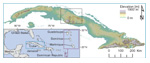 Figure 1
Cuba with elevation as color ramp. Black outline is area mapped in Figure 3. Inset shows location of Cuba in relation to North America.
Here, we present and interpret extensive new data characterizing river waters in central Cuba, the result of a bi-national, collaborative field campaign. Biogeochemical analyses allow us to address fundamental geologic questions, such as the pace of chemical weathering in the tropics, as well as applied environmental questions related to the quality of river water and human impacts on a landscape where small-scale, sustainable farming has replaced substantial swaths of industrial agriculture (The Guardian, 2017).
Background and Methods
Cuba’s wet, warm tropical landscape is dominated by mountains (up to 1917 m above sea level [asl] in the east, 500–700 m asl elsewhere) running parallel to the north and south coasts (Fig. 1). Mainly forested uplands descend into farmed rolling plains and mangrove-lined, low-lying coastal estuaries. The climate is summer-wet and winter-dry with precipitation delivered both by trade-wind showers and by larger tropical storms.
The diverse geology of Cuba reflects its tectonic setting at the boundary of the North America and Caribbean plates. Central Cuban basement lithologies include accreted igneous rocks, sediments (clastic, carbonate, and evaporite) formed along passive margins, obducted ophiolite, and island arc rocks (Iturralde-Vinent et al., 2016). This basement is unconformably overlain by slightly deformed, younger marine and terrestrial sedimentary rocks (Iturralde-Vinent, 1994). Where river water has interacted with these diverse rocks, surface water chemistries should reflect the composition of underlying rock units.
Agriculture has been practiced in Cuba for centuries. Indigenous people cultivated cassava, yucca, and maize (Cosculluela, 1946). Spanish colonization from 1492 brought slaves, large-scale sugar agriculture, and cattle farming (Zepeda, 2003). Following Cuba’s independence from Spain in 1898, sugar production in Cuba quadrupled under U.S. influence (Whitbeck, 1922). When Cuba allied with the Soviet Union in 1959, industrialization of the sugar industry to increase yields and exports became a central goal (Pérez-López, 1989). By the 1980s, Cuba boasted the most mechanized agricultural sector in Latin America (Febles-González et al., 2011); however, the collapse of the Soviet Union in 1991 catalyzed Cuban adoption of reduced tillage, organic soil amendments, the use of cover crops, and the replacement of fuel-hungry tractors with domesticated draft animals, including horses and oxen (Gersper et al., 1993).
Surface water biogeochemical monitoring in central Cuba has focused mainly on reservoirs. In central Cuba, water chemistry data (1986–2005) from four reservoirs, representing two river systems and four basins with varied geology (Betancourt et al., 2012) showed that the primary control on major ion concentration is rock weathering upstream; there was no statistically significant difference in water chemistry between dry and rainy seasons in three of the four basins.
In August 2018 (the wet season), we collected water samples from 25 river basins in central Cuba. We selected these sites to encompass a range of land uses, underlying upstream rock types, discharges, and basin sizes, while avoiding rivers that had major dams (Figs. 2 and 3N). See the GSA Data Repository1 for detailed methods. Our analysis assumes that the concentration of cations and anions we measured are representative of annual average values (Godsey et al., 2009).
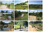 Figure 2
Common Cuban landscapes and example sample sites. (A) Sugarcane and dirt roads are common on the island. (B) Cattle grazing on cleared fields. (C) Citrus groves on slopes in southern field area. (D) Horses were frequently in rivers, CU-132. (E) Plane-bed sand and gravel channel with cows in the river, CU-101. (F) Large point bar flooded during Hurricane Alberto showing dynamic range of river flows over time, CU-114. (G) Boulder/bedrock channel during conductivity measurement, CU-115. (H) Bedrock channel, CU-114. (I) Low flow sample site in incised channel, CU-122. Locations identified by letter in Figure 3N.
Media
Taxonomy
- River Studies
- Performance Benchmarking of River