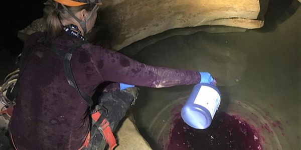
Dye Tracing Illuminates Pathways through Mammoth Cave National Park
Published on by Marcus Miller, Digital Marketing Manager at In-Situ in Case Studies
Dye Tracing Illuminates Pathways through Mammoth Cave National Park
Overview
Researchers from Crawford Hydrology Laboratory are conducting dye tracing studies of the Great Onyx Basin in Mammoth Cave National Park, Kentucky, to enhance our understanding of karst hydrogeology and lay the groundwork for future studies on sustainable practices in the park and the role of karst landscapes in the carbon cycle.
Challenge
Extensive dye tracing studies in the 1970s and 80s mapped and defined the majority of karst geography in Kentucky’s Mammoth Cave National Park. But one area of the park received little attention until the early 2000s. Crawford Hydrology Laboratory, part of Western Kentucky University’s Applied Research & Technology Program, is continuing dye tracing studies in the Great Onyx Groundwater Basin to develop a high-resolution model of the “internal plumbing” of the aquifer.
This kind of three-dimensional model can’t be achieved using qualitative methods alone. Charcoal monitoring only provides point-to-point connections and grab sampling requires significant effort for lower-resolution data. Continuous monitoring, on the other hand, offers insight into the exact time of travel and dye mass recovery and allows researchers to interpret the breakthrough curve for other aquifer characteristics. In order to further characterize and map Great Onyx Basin, Crawford Hydrology Laboratory needed a method of continuous data collection that would provide high-resolution data while reducing effort and cost in the field and at the lab.
Solution
To get the quantitative data they need, Crawford Hydrology Lab and students from Western Kentucky University set up an Aqua TROLL 600 at Great Onyx Spring, which had been established as a resurgence point for Great Onyx Basin by previous dye tracing studies. The Aqua TROLL was equipped with...
Taxonomy
- Hydrology
- Groundwater
- Hydrological Modelling
- Hydrogeology
- Hydrology
- Groundwater Recharge
- Groundwater Assessment
- Groundwater Modeling
- Hydrological Automation
- Groundwater Pollution
- Groundwater Prospecting
- Groundwater Mapping
- Surface-Groundwater Interaction
- Hydrologist
- Social Hydrology
- Hydrological Modelling
- Isotope Hydrology
- Groundwater Salinisation
- Hydrology Cycle
- Hydrology Nutrient Cycling
- Groundwater Quality & Quantity
- Experimental Hydrology Models
- Geo-hydrology
- Hydrogeologist
- Hydrogeology & Hydrochemistry
- Hydrological Investigation
- Groundwater Resource
- M Sc Hydrogeology
- Public Water System and Groundwater Issues
- Groundwater Surveys and Development
- Groundwater flux
- Hydrological modelling of climate change
- Karst Hydrogeology
- Groundwater monitoring and assessments
- Surface Water Hydrology
- Groundwater Remediation
- Hydrogeologist
- Groundwater Data Scientist
- Hydrology
- Desert hydrology , rainfall -runoff relationships, and flood hazard assessment
