Studying water quality with satellites and public data
Published on by Water Network Research, Official research team of The Water Network in Technology
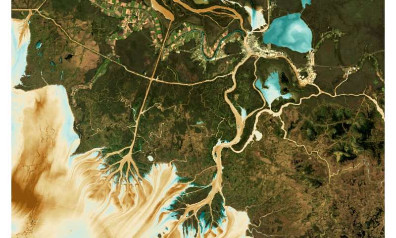
This visual shows how AquaSat can be used to predict Total Suspended Sediment in the Wax Lake and Atchafalaya Deltas, where brown colors are high sediment concentrations and blue values are low. Credit: Matthew Ross/Colorado State University
Access to abundant, clean, water for drinking, recreation and the environment is one of the 21st century's most pressing issues. Directly monitoring threats to the quality of fresh water is critically important, but because current methods are costly and not standardized, comprehensive water quality datasets are rare. In the United States, one of the most data-rich countries in the world, fewer than 1% of all bodies of fresh water have ever been sampled for quality.
In a new paper, AquaSat: a dataset to enable remote sensing of water quality for inland waters, a team led by Colorado State University Assistant Professor Matt Ross matched large public datasets of water quality observations with satellite imagery to address the challenges of measuring water quality efficiently and cost-effectively.
Threats we can't fully understand—yet
According to Ross, a watershed scientist in the Department of Ecosystem Science and Sustainability, there are many threats to water quality, including nutrients from agricultural runoff that support algae blooms; sedimentation in reservoirs that cause distribution challenges; and dissolved carbon from decaying leaves that interrupts chemical reactions that keep water clean and safe for drinking.
For the most part, government entities monitor water quality in the U.S. by sending scientists into the field to measure variables like the amount of chlorophyll (from algae), concentrations of suspended sediment, dissolved organic carbon, and water clarity in person.
But, as Ross and his team explain, to fully understand and inventory changes in water quality, a far larger dataset is required; that in turn requires more and more people to do field sampling, which is very expensive and unlikely to completely address the problem.
Instead, the team suggests using remote sensing from satellite imagery could be a way to vastly expand our understanding of variation in water quality at continental scales, with little extra cost for sampling.
SOURCE by Rob Novak, Colorado State University
Media
Taxonomy
- Satellite
- Integrated Water Resources Management (IWRM)