USGS updates SPARROW streamflow modeling tool
Published on by Water Network Research, Official research team of The Water Network in Academic
The U.S. Geological Survey (USGS) has released new interactive mappers and models for its online SPAtially Referenced Regression On Watershed attributes (SPARROW) tool.
The new models estimate streamflow and the concurrent yields of total nitrogen, total phosphorus, and suspended sediment in both monitored and unmonitored inland stream reaches across the country as they feed into larger water bodies. Through SPARROW’s regionalized models, land and resource managers can better prioritize water-quality improvement efforts based on historical hydrological data in their specific area, the agency said in a release.
Update improves information quality
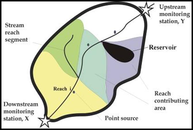
In this U.S. Geological Survey diagram illustrating the SPARROW methodology, the dark black line represents the drainage boundary for a watershed. At the downstream end of the watershed is a monitoring site that can be used for model calibration. Upstream of the monitoring site, the streams in the watershed are broken up into a number of segments referred to as stream reaches. Drainage boundaries and the contributing areas for stream reaches are defined and illustrated by separate colors. Image courtesy of U.S. Geological Survey
SPARROW was, until recently, predicting runoff and water movement using average annual flow data from 2002. USGS researchers updated the model to use 2012 data, providing a timelier and more accurate picture of streamflow and mean contaminant loads.
The new interactive mappers and models cover five U.S. regions: the Southwest, Pacific, Southeast, Midwest and Northeast. These regionalized models allow investigators to examine a range of issues such as the effects of irrigation in the dry Southwest, nutrient sources in the agricultural Midwest, or how water resource recovery facilities in the densely populated Northeast influence streamflow and pollutant trends.
New regional models provide nutrient and sediment loading data at a resolution of 2 km2 (0.7 mi2) – a massive improvement over the previous resolution of about 132 km2 (51 mi2), the agency said. That makes SPARROW a more accurate tool for identifying nutrient and sediment sources, particularly in large watersheds.
“The models provide an improved understanding of where on the landscape and from water sources water, nutrients, and sediment in streams and lakes originate,” the agency said in a release.
Recent updates also apply to RSPARROW, an open-source version of the tool that extends the program’s capabilities and allows individual developers to modify the program to their needs.
History of helping
Models created under the SPARROW program have a long history of helping scientists and watershed managers since its initial development in 1997.
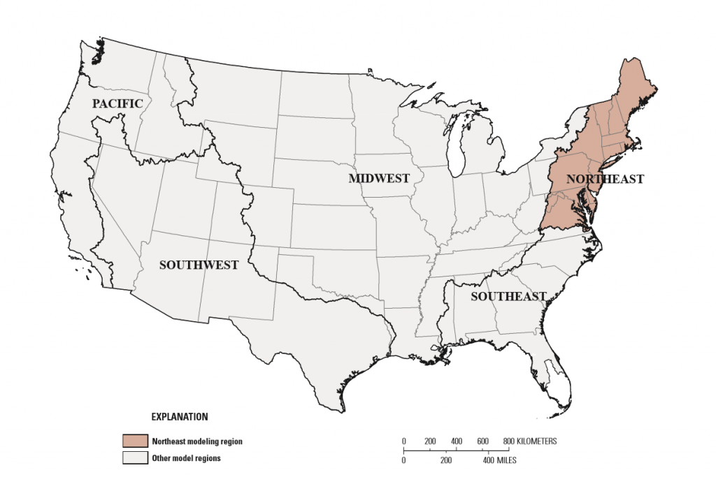
A map of the regions covered by the updated U.S. Geological Survey SPARROW models: the Southwest, Pacific, Southeast, Midwest and Northeast. Through SPARROW’s regionalized models, land and resource managers can better prioritize water-quality improvement efforts based on historical hydrological data in their specific area. Image courtesy of U.S. Geological Survey
They have been applied at the national scale, for example, to estimate the natural background levels of nutrients in rivers and streams. Practitioners have also used regional models in Chesapeake Bay rehabilitation efforts to identify the most significant sources of nitrogen in the watershed, to simulate the impacts of climate change to Lake Michigan, and to assess the effectiveness of various nutrient runoff limitation techniques in the Midwest.
According to the agency, the program’s developers are currently working on models not based on a single time period. Dynamic versions will account for temporary storage of contaminants and will be able to simulate seasonal variations.
Learn more about the SPARROW tool at the USGS website.
— Will Fowler , The Stormwater Report
Taxonomy
- Watershed Management
- Watershed
- Integrated Watershed Management
- Groundwater Modeling
- 3D Modelling
- Modeling Tools