NASA’s Next-gen Approach to Studying Earth’s Climate
Published on by Water Network Research, Official research team of The Water Network in Technology
NASA announced six small satellite missions, which range in size 'from a loaf of bread to a small washing machine', designed to help in the study of Earth's climate, environment and water.
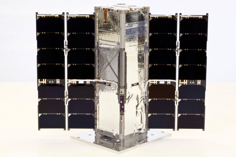
A front view of the RAVAN satellite that uses novel VACNT technology for absorbing light in space. Photo: Johns Hopkins APL/Blue Canyon Technologies.
Although different in scope, the satellites do have some key features in common. For example, their size allows them to easily join existing launches, and they open doors for testing technologies that may have otherwise been cost-prohibitive. This additional research potential assists NASA in its efforts to study Earth’s changing climate, a goal especially relevant today.
Here they are:
- RAVAN (Radiometer Assessment Using Vertically Aligned Nanotubes)
About the size of a loaf of bread, the RAVAN satellite is on a mission to show that a small instrument can be a powerful tool in understanding Earth’s radiation measurements and, therefore, predicting future climate behavior. There are two key technologies behind RAVAN: a gallium calibration source to track the sensor as it breaks down, and the use of Vertically Aligned Carbon Nanotubes (VACNTs) particularly well-suited for absorbing radiation—or light—in space.
Part of RAVANs appeal is its potential to use small instrumentation to provide more accurate measurements of two key indicators of climate change: earth radiation imbalance (ERI) and earth radiation budget (ERB).
“Today, measurement of Earth’s energy balance from space is limited in part by spatial/temporal sampling by a small number of satellites on-orbit—they can’t be everywhere all the time. What is needed is a constellation of radiometers, perhaps a few dozen flown on small satellites, for 24/7 global observation. Continuous coverage is enabled by smaller, less expensive sensors, and APL’s RAVAN demonstrates such a sensor prototype,” Schwartz said.
- TROPICS (Time-Resolved Observations of Precipitation structure and storm Intensity with a Constellation of Smallsats)
Led by William Blackwell of the Massachusetts Institute of Technology’s Lincoln Laboratory, TROPICS is a mission to understand how tropical cyclones develop by looking inside hurricanes using rapid-revisit sampling. As one of two proposals selected to NASA’s third Earth Venture Instrument competition program, TROPICS is a constellation of 12 CubeStats—nanosatellites normally sized 10 x 10 x 10 cm, but extendable. For TROPICS, each CubeSat comes in at 8.5 pounds and 1 foot long. Launching into three orbital planes and harnessing the power of scanning microwave radiometers, TROPICS can monitor changes in the precipitation, humidity, temperature and cloud properties of hurricanes every 21 minutes.

The instruments of the TROPICS mission to understand how tropical cyclones develop. Photo: MIT Lincoln Lab
- CYGNSS (Cyclone Global Navigation Satellite System)
Led by the University of Michigan for NASA, CYGNESS is a constellation of eight identical satellites that fly in formation. Using reflection from GPS signals found on the surface of the ocean, CYGNESS can monitor wind intensity to better analyze and predict hurricanes and other tropical storms. The CYGNESS mission launched on December 15, 2016 from Cape Canaveral in Florida. According to a message Principal Investigator Chris Ruf posted on the CYGNSS Launch Blog, the launch was successful, and they have “successfully contacted each of the eight observatories on [the] first attempt.” The next step, of course, is to examine the data.
- IceCube
Led by Dong Wu at NASA’s Goddard Space Flight Center, IceCube takes a new spin on measuring cloud ice: the deployment of the first 874 GHz submillimeter high-frequency microwave radiometer on a nanosatellite. Scientists often look to cloud ice measurements as they’re forming climate models, so effective measurement is vital for accurate projections. Remote sensing from space can allow for increased depth of cloud penetration, as the higher frequency produces more brightness for ascertaining the size of ice particles. The ultimate goal of the IceCube mission is to eliminate risks associated with the 874 GHz receiver for future use.
- MiRaTa (Microwave Radiometer Technology Acceleration)
MiRaTA: Microwave Radiometer Technology Acceleration
Led by Kerri Cahoy of the Massachusetts Institute of Technology, MiRaTa is slated to launch early this year. MiRaTa’s objective is to test new CubeSat technologies, like a new method for radiometer calibration, innovative GPS receiver and antenna setup, and the validity of multi-channel radiometers operating at varying frequencies.
According to NASA, MiRaTa also “packs many of the capabilities of a large weather satellite into a spacecraft the size of a shoebox,” collecting valuable measurements—such as data—on water vapor and cloud ice that can be valuable for tracking storms and forecasting weather.
- HARP (Hyper-Angular Rainbow Polarimeter)
Led by Vanderlei Martins of the University of Maryland Baltimore County, the goal of the HARP mission is to measure the properties of ice particles, cloud water and aerosols in the atmosphere from multiple perspectives. With its hyper-angular polarimeter, HARP features a field of view imager that produces accurate and wide images of three polarization states. In addition, the mission aims to open doors for future developments in aerosol-cloud instruments that are cost-effective and space-worthy.
Read more: Laboratory Equipment
Media
Taxonomy
- Technology
- GIS
- Climate Change Resilience
- Climate Protection
- Water
- Climate Change
- GIS & Remote Sensing
- Climate
- Satellite