GIS Technology Helping Farmers on Malta
Published on by Water Network Research, Official research team of The Water Network in Technology
Satellite data imagery can help local agriculture reap better results, academic and software engineer Steve Zerafa says. He was interviewed by the reporters of 'The Times of Malta'.
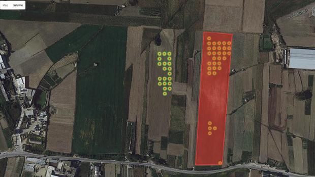
Satellite data shows that field was ploughed in late April 2016. Same field was planted during summer 2015 and the crops had few weeks left to reach maturity.
Apart from the satellite systems which we are already using are there any other systems which could be beneficial if applied locally?
I could mention three systems which in my opinion are not only beneficial but it is worth investing into.
The first is agriculture monitoring. Satellite imagery can provide for mapping and observation of habitats, crops and trees, in relation to water usage. In the context of fresh water scarcity, the system could lead to a peaceful coexistence of fresh water supply and the agricultural sector in Malta and Gozo.
Coastal monitoring is another potential benefit for Malta and Gozo, as one can monitor coastal and marine developments. A satellite image, reproduced, was taken in September 2016 and could clearly show points for further investigation. The ship going out of Valletta harbour is leaving a trail which is quite narrow and more than 15km long.
One would ask whether this is a ship wake, an oil trail or something else. In this case software algorithms could be worked out which would indicate whether such trails contain oil or not. Furthermore, satellite imagery could provide for monitoring of atmospheric aerosols, which are created by volcanoes, desert dust or through the burning of coal and oil.
Apart from these applications, I am sure that other usages could also be applied locally and software engineers could be creative and come out with more innovative ideas.
What are the main benefits of applying satellite data imagery to agricultural usages?
Satellite systems offers the potential to observe the ongoing dynamics within the selected agricultural lands in a very detailed manner, on a weekly basis. The ability and knowhow to derive different measurements from satellite given data can therefore create potential applications and benefits. These include: the mapping and classification of crops; crop modelling and yield forecasting; crop health monitoring; pest and disease detection and management planning; and water management planning.
What are the main usages that you have proposed?
The proposed system aims to use satellite data and combine it with existing irrigation technologies and fertilisation systems to improve the water management usage and monitoring the growth of crops. Sometimes farmers during irrigation may exceed the amount of water needed for the optimum results, and hence it will result in water not being irrigated uniformly. If crops are given the amount of water needed, no more no less, yield could be improved. Local farmers tend to water more amounts than required, which will lead to excess of water usage when it rains.
The main target of the proposed system is to get to a point where the big data available from the satellites is used to assist automated irrigators and indicate the best amount of water for each field for each crop, every day.
All gathered data from satellite imagery in relation to the fields should than be kept for future comparisons, trends and analysis.
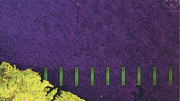
Photo taken by Sentinel 1 satellite showing trails by ships. The Sentinel 1 satellite was designed to detect oil spill and pollution.
In what ways do such usages benefit both farmers and consumers?
There are plenty of benefits. First is the reduction of manual work. Recently, while discussing some ideas with a local farmer, he stated that he spends from 40 to 50 per cent of his working time irrigating and in summer he spends even more time. He further highlighted that he is constantly on the move to inspect crops in various fields located in different locations, because in farming it is critical to monitor all aspects of land.
Such systems can help farming operate in a more efficient manner. Satellite imagery offers access to high definition imaging of every inch of land on a weekly basis. This could help farmers to react to crop stress in a timely manner to protect yield as well as reduce physical movement between fields thus eliminating fuel costs and physical stress.
Another benefit is better decision making. Using satellites, historical trends and statistics, farmers will equip themselves with better decision making tools. Having such tools they will be in a better position to decide the best time to crop their products as to obtain the maximum yield.
While better management tools can increase yields, combining data with automated irrigation systems, and automated nutrition systems, will considerably reduce labour costs, thus managing time more effectively.
These advantages could be beneficial also for consumers and the market in general, who would gain more local fresh products, better flavour and of better quality than the products we import. If costs for farmers decrease, and yields increase during the crop season, products supply will increase and therefore prices will reduce. Farmers could potentially become more competitive when prices are compared to imported products.
Furthermore, once the whole system is applied at a national level, we can understand which crops are going to be scarce in the coming season, and also identify which crops are viable to be planted in Malta.
What environmental benefits do such usages present?
The major benefit for such usage is the decrease of water use in irrigation. From the systems that I have installed I can say that more than 10 per cent reduction in water usage was observed and this was achieved with a minimal use of satellite data and only on selected crops. I am confident that when this study is completed, all data is in hand and the whole proposed system is in place, the percentage reduction in water usage will be more than double.
Another environment benefit is controlling the use of fertilisers, starting with the three main nutrients nitrogen, phosphorus and potassium. In conventional farming these fertilisers are applied over fields at certain times during the year. This leads to either over-application in some places or under-application in others. If over applied there is a cost to the environment, emitting nitrogen and phosphorus into ground and surface waters or to other areas of the field where they are not required. If under-applied this will come at the expense of the crop. Satellite data can help in this regard and display whether low amounts or high amounts of organic fertiliser was applied.
Other environment advantages are guaranteed if using such technologies, such as to trace products to fields and ultimately to farmers, monitor use of land within a national context, and auditing usage of water for various crops, thus leading to effective policy planning. Finally, a similar system could be adopted to trace trees at national level and develop national databases, for proper monitoring and policy planning.
In conclusion, combining satellite images with algorithms and physical technologies leads to what is known as precision agriculture or smart farming. This is becoming one of the most technologically involved industries. Regardless of where a person is in the world, there is free satellite imaging data available for everyone which gives equal chances to everybody to be more sustainable in agriculture. The benefits are huge if the potential of this technology is maximised, and range into various environmental and health sectors.
Read full interview at: The Times of Malta
Media
Taxonomy
- Agriculture
- Irrigation
- Agriculture
- Technology
- GIS & Remote Sensing Technology
- GIS
- Data Management
- Consumption
- Irrigation Management
- GIS Spatial Analysis
- GIS & Remote Sensing
- Satellite