SmallSat GIS Revolution
Published on by Water Network Research, Official research team of The Water Network in Technology
Tiny satellites poised to make big contributions to essential science and water mapping.
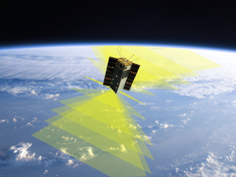
Tiny CubeSats are ready to be our eyes in the skies. Earth Background: NASA; HARP Spacecraft: SDL; Montage: Martins, UMBC, CC BY-ND
These SmallSats are poised to change the way we do science from space. Their cheaper price tag means we can launch more of them, allowing for constellations of simultaneous measurements from different viewing locations multiple times a day – a bounty of data which would be cost-prohibitive with traditional, larger platforms.
Called SmallSats, these devices can range from the size of large kitchen refrigerators down to the size of golf balls. Nanosatellites are on that smaller end of the spectrum, weighing between one and 10 kilograms and averaging the size of a loaf of bread.
Initial CubeSats were designed as educational tools and technological proofs-of-concept, demonstrating their ability to fly and perform needed operations in the harsh space environment.
Like all space explorers, they have to contend with vacuum conditions, cosmic radiation, wide temperature swings, high speed, atomic oxygen and more. With almost 500 launches to date, they’ve also raised concerns about the increasing amount of “space junk” orbiting Earth, especially as they come almost within reach for hobbyists. But as the capabilities of these nanosatellites increase and their possible contributions grow, they’ve earned their own place in space.
SmallSats – big science
Hyper Angular Rainbow Polarimeter (HARP) payload is designed to observe interactions between clouds and aerosols – small particles such as pollution, dust, sea salt or pollen, suspended in Earth’s atmosphere. HARP is poised to be the first U.S. imaging polarimeter in space.
HARP is designed to see how aerosols interact with the water droplets and ice particles that make up clouds. Aerosols and clouds are deeply connected in Earth’s atmosphere – it’s aerosol particles that seed cloud droplets and allow them to grow into clouds that eventually drop their precipitation.
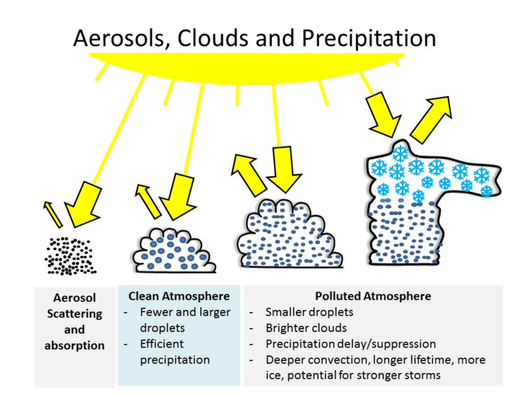
Pollution particles lead to precipitation changes. Martins, UMBC, CC BY-ND
This interdependence implies that modifying the amount and type of particles in the atmosphere, via air pollution, will affect the type, size and lifetime of clouds, as well as when precipitation begins. These processes will affect Earth’s global water cycle, energy balance and climate.
When sunlight interacts with aerosol particles or cloud droplets in the atmosphere, it scatters in different directions depending on the size, shape and composition of what it encountered.
HARP will measure the scattered light that can be seen from space. We’ll be able to make inferences about amounts of aerosols and sizes of droplets in the atmosphere, and compare clean clouds to polluted clouds.
In principle, the HARP instrument would have the ability to collect data daily, covering the whole globe; despite its mini size it would be gathering huge amounts of data for Earth observation. This type of capability is unprecedented in a tiny satellite and points to the future of cheaper, faster-to-deploy pathfinder precursors to bigger and more complex missions.
Read more on: The Conversation
Media
Taxonomy
- Technology
- GIS & Remote Sensing Technology
- GIS
- IT
- Hydrological Modelling
- GIS for network
- Surface Flow Analysis
- Hydrological Modelling
- Geographical Information Systems
- Geographical Information System
- GIS Spatial Analysis
- IT
- GIS & Remote Sensing
- Satellite