More Precise Groundwater Recharge Models
Published on by Marina A, Previously Key Account and Content Manager at AquaSPE AG in Academic
University of Freiburg hydrologist Dr. Andreas Hartmann believe that climate change impact models are not precise enough due to the missing information of the hydrological processes.
Groundwater recharge estimates were revised and it is noe presumed they were off and are much higher than previously thought.
The estimations for large-scale models, for entire continents were extremely underestimated and neglected the groundwater recharged from surface runoff.
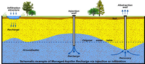
Groundwater is an important resource of water. To have an overview of drinking water supply, it is very important to know how much groundwater is recharged.
Researchers have compared two different hydrological models and came to the conclusion the estimations were imprecise.
One of the models didn’t stress out the subsurface heterogeneity well enough and the other did. It was a continental model, made by them, which focused on the differences in soil thickness and its variations in permeability. This means the retention of water in different types of soil was taken into account.
Researchers compared karst regions in Europe, North Africa and the Middle East.
Groundwater in Karst region
Karst topography is an area from the dissolution of soluble rocks. Its special characteristic are underground drainage systems with sinkholes and caves.
Karst regions have a heterogenous below the surface and easily eroded and disintegrated due to chemical weathering.
This heterogeneity means that the ground has great differences in permeability and depth.
Hereby, it is crucial to include this data in groundwater recharge estimations to get representable and precise results.
They showed that the estimations of the previous model incorrectly showed the lack of available water depending on the region.
The previously made models can be improved to include the karst region estimations and predict water shortages, drought or floods and the water status in a certain region more correctly.
Media
Taxonomy
- Soil
- Hydrology
- Groundwater
- Hydrology
- Groundwater Recharge
- Groundwater Modeling
- Groundwater Mapping
- Hydrologist
- Geo-hydrology
- Groundwater Resource
2 Comments
-
In Algeria the experience of the artificial recharge of the tablecloths was realized in the plain of the mitidja about 30km to the ud of algiers
-
The ideas in article are so true, and propositions are very helpful to a limited extend which is taylored by precipitation. I am totally with the author. Lucky we are in my country that there was a huge visual survey of rock formations followed by exploration drilling, done in 1960-70ies. And the full detailed summary including water test results are published as a book and free to obtain. I would add something to the first image from the article, that comes from my personal work and experience (I was looking for water to deliver to my orchard in remote mountains area): in places like ours with rough landscape and continental climate, there are good opportunities to build a network of dams there where there are karst formation openings in upper grounds, to retain winter water and flood water as infiltration part of the process. Not much of geology survey was needed in my case, to test if it works, just but two-three years of continuous monitoring of spring and wells water properties. In my particular case, we are now to build those simple small size dams already. Another thing we do is as we don't need much water we can pump out of dug wells in winter time, we direct it into the same place during the winter - those upper karst layers. We do it for 3-rd winter in row - and debit of corresponding well is doubled, praise God, and dynamic levels gap is much shorter. And the last thing - this can be very simple yet environment-friendly technique, suitable for implementation by small size farms and village communities - a key factor in this so unstable and divided world!