How Oroville Went from Drought to an Overflowing Dam in Just 2 Years
Published by Water Network Research, Official research team of The Water Network in Academic
Oroville was a potent symbol of a state dying of thirst. Today, California’s cup runneth over.
It was only two years ago that the receding waters of Lake Oroville – California’s second largest reservoir, located about 70 miles north of Sacramento – became the defining image of the state’s historic drought.
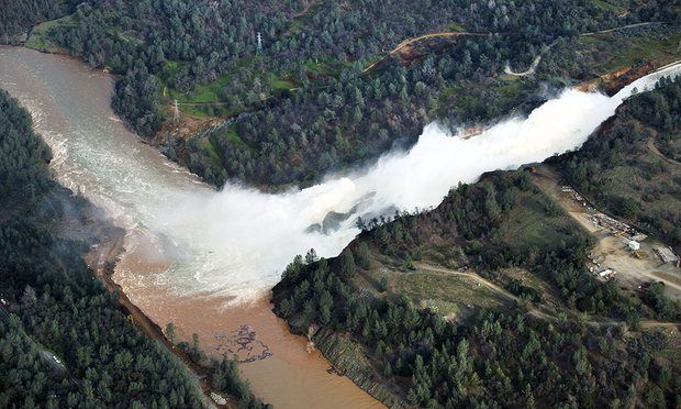 This weekend, water poured over the Oroville dam’s emergency spillway for the first time in its history. At a press conference on Tuesday, a California dam inspector says authorities may never know the exact causes of the blowouts below the dam.
Eric Holland of the state’s department of water resources’ dam-safety division said authorities often never discover in these cases what exactly happened, because floodwater has washed out everything at the scene.
The overflow did not proceed to plan: unexpected erosion of the emergency spillway prompted fears among state officials that the spillway was at risk of imminent collapse. Nearly 200,000 people living downstream were ordered to evacuate, and it remains unclear when they will be allowed to return home.
After years of drought, northern California has been inundated with more than twice as much precipitation as normal since 1 October. The precipitation is also coming in an inconvenient and unseasonal format: rain.
Typically, a significant amount of a winter season’s precipitation stays frozen in snowpack until spring. But this year, much of that precipitation has been rain, and even when snow has fallen, it has been melted soon thereafter by warm rains.
Lake Oroville typically reaches its highest level in June, after the snow melts. To reach such a peak in mid-February is “extraordinary”, Carlson said. More rain is expected later this week.
Roger Bales, a professor of engineering with the University of California’s Sierra Nevada Research Institute, said that the overabundance of water in Lake Oroville was in part attributable to climate change.
“It doesn’t take much warming to change snowstorms into rainstorms,” he said. “With a warmer climate, we get these winter storms, which dump rain rather than snow.”
To a certain extent, this rainy season tracks with what Carlson says has become “a little bit of a cliche” – the idea, prevalent among “old-timers”, that droughts end in floods.
But to Michael Dettinger, a research hydrologist for the US Geological Survey, the cliche has grounding in scientific fact.
“California’s year-to-year fluctuations of precipitation amounts swing more broadly from wet to dry than any place in the country, and always have,” Dettinger said.
Dettinger has analyzed how historical droughts have ended in California and other places. He found that 40% of droughts in northern California “ended abruptly with the arrival of atmospheric river storms”, which took conditions from drought to “above normal wetness” within days.
“Floods or droughts, that is pretty much just California for you,” Dettinger said.
Still, Dettinger cautioned against over-attributing the extreme event at Lake Oroville to climate change. While he is convinced that climate change will amplify the drought/flood cycle, he is not convinced that it has had an impact so far.
“California’s climate has always had the potential for a year like this,” he said. “So far, except for how quickly [not how much] the precipitation has piled up, there is nothing record-breaking here.”
Source: The Guardian
Tags
Category: Academic
- Water
- Hydrology
- Environment
- Drought
- Climate Change
- Hydrology
- Flood management
- Flood
- Water