Dubai Canal Flows
Published by Water Network Research, Official research team of The Water Network in Government
First image of the now-full Dubai Canal from space.
Two weeks ago water was released into the Dubai Canal, which now means the waterway flows from the creek all the way to the ocean. Then the waterfall along Sheikh Zayed Road starting flowing.
Today’s news? The first image of the full canal has been captured from space by the DubaiSat-2, which is owned and operated by the Mohammed Bin Rashid Space Centre.

Dubai once

Dubai with new canal
The latest photo also shows just how much Jumeirah’s beach and shoreline has extended as part of the project.
It gives you an overview of the location of the new bridges to cross the canal and how much of the city has been built to sit snugly along the water’s edge (an indication perhaps that the canal was in the works long before we all knew about it).
Here’s a photo from Dubai Media Office that shows the water running from Sheikh Zayed Road, past Safa Park, all the way to the beach in Jumeirah:

The 3.2-kilometre canal links Business Bay with the Arabian Gulf, and has turned areas of Dubai like Satwa, Downtown, Zabeel, Oud Metha, Karama and Bur Dubai into one huge island (as they are now completely waterlocked).
When the entire project is finished we’ll get a new Jumeirah Beach Park, a mall with a park on top of it, a 7km running track and apartments that look over Safa Park.
This month all of the major roads and pedestrian bridges will open along the Canal (however it will then take a while for the residences, restaurants and hotels etc to be built and opened).
In fact, both of the bridges over Sheikh Zayed Road are complete and open, both the the Al Wasl Road and Jumeirah Beach Road bridges are finished, and the pedestrian bridges over the canal near Safa Park look to be almost finished.
WHAT DUBAI CANAL WILL ADD TO THE CITY…
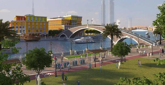
The pedestrian walkways
There will be three pedestrian bridges that will run along the three-kilometre-long Dubai Water Canal, there will also be running tracks, sitting areas looking over the water, smart lighting (that can be controlled by an app) and lots of greenery.
‘The Walk’ at Dubai Water Canal will connect with the current Jumeirah Beach running track, meaning a 7km-long continuous track for joggers.
The area will also be very safe, due to smart surveillance cameras focused on pedestrians with face-recognition technology.
So will we be able to live, stay and shop along the canal? Of course! Property developments will run along both banks of the canal – with 5,345 residential units planned, as well as 948 hotel rooms. The areas will be called Gate Towers, Jumeirah and Peninsula.
There will be four residential towers linked with Safa Park, as well as 211 residential units right on the water.
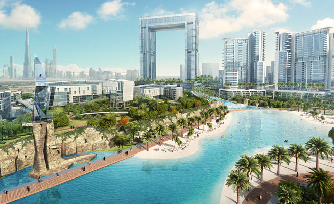
The Gate Towers mall is seen in the centre of this photo.
In other good news, Jumeirah Beach Park will reopen, and the stretch of beach on the much-loved, currently-closed park will extend by one kilometre as it will run out over the Canal’s peninsula. The peninsula area will also feature 60 marinas, 1,817 residential units, 957 five star hotel rooms and 347 retails outlets and restaurants.
The Gate Towers bridge at the entrance of the canal to the Arabian Gulf will feature a three-level mall that will be built above the Canal and span 300,000 square metres. The mall will hold 434 retail outlets and restaurants.
The coolest bit? The roof of the mall will be a park – yes, as in greenery, and it will look out over Safa Park.
THE CONSTRUCTION
The huge project was split into three contracts by the RTA:
1) Phase one was made up of the Dhs580 million development of eight lanes of bridge in each direction on Sheikh Zayed Road, and the course for the Canal that will flow under Sheikh Zayed Road. This has been completed.
2) The second phase was the Dhs384 million construction of bridges on Al Wasl Road and Jumeirah Beach Road that will allow yachts of up to 8.5 metres in height to navigate the canal along these roads. It will also include a multi-tier interchange to link traffic movement between Al Wasl, Al Hadiqa and Al Athar Roads.
3) The final phase is the largest – at Dhs802 million – and involves the digging of the Water Canal, and building the sides of the Canal that will link Dubai Creek with the Arabian Gulf from Sheikh Zayed Road, through Al Safa Park and Jumeirah 1. This phase is still active but is almost complete, and it also includes the construction of three pedestrian bridges, four marine transit stations, and a manmade peninsula along Jumeirah Park.
Source: What's On
Tags
Category: Government
- Canals
- Urban Water
- Integrated Infrastructure
- Landscape & Urban Design
- Urban Design
- Canals