New Bathymetric Datasets Simplify Coastal Monitoring
Published on by Water Network Research, Official research team of The Water Network in Technology
New multi-scale shoreline products from TCarta Marine are designed to make shorelines easier to monitor.
Offered in GIS-ready vector format, the Shoreline data sets are derived from satellite imagery and accurately delineate mean sea level for the land-water interface at coastal areas around the world.
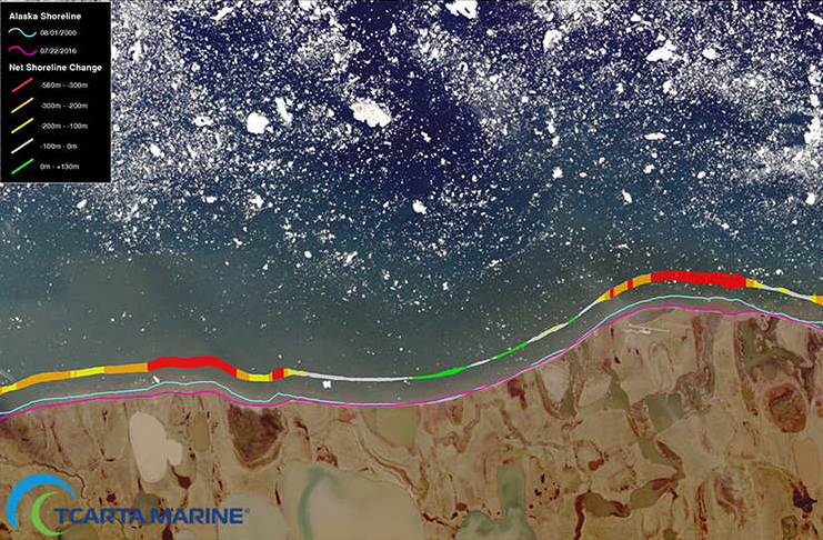
Image source: TCarta Marine
TCarta Marine is a global provider of marine geospatial products. It is creating the vector shoreline products at global, national and local scales for mapping applications as diverse as environmental protection, coastal infrastructure development and flood insurance rate calculations.
Many of the shoreline products are available off-the-shelf, while others are custom derived from archived or newly collected satellite imagery.
Available off-the-shelf, the global vector shoreline products are 1:60,000-scale vectors derived from U.S. Landsat satellite imagery. The data sets include 2 million linear kilometers of coastlines, 400,000 islands, and thousands of rivers and streams. This scale provides broad-area resolution in a manageable file size ideal for monitoring global change over time.
The national vector shoreline products are 1:20,000-scale vectors created for coastal zone management and environmental monitoring of specific regions.
Derived from 10-meter-resolution European Sentinel 2A/2B imagery, these products are available both on demand and off the shelf. Vectors for Africa, South Asia and the Bahamas have been created with additional regions added and updated continuously.
“Shorelines are constantly transformed by climate change and erosion,” Goodrich says. “With our national vector shoreline, we are able to deliver frequent data updates that are ideal for ongoing analysis and monitoring of rapidly changing coastlines thanks to the rapid revisit of the Sentinel constellation.”
A classified national vector shoreline is also being derived from the multispectral Sentinel imagery for use in complex coastal ecosystem modeling applications. These 1:20,000-scale vectors contain classified polygons differentiating land cover types such as sand, rock, vegetation and some man-made features, including Causeways and Jetties.
Read full article: Point of Beginning
Media
Taxonomy
- GIS & Remote Sensing Technology
- Coastal Engineering
- GIS for network
- Coastal
- Water Monitoring
- Coastal Erosion
- GIS Spatial Analysis
- Monitoring Technology
- GIS & Remote Sensing