Researchers Find Urban Development Dramatically Increases Stream Flow
Published on by Water Network Research, Official research team of The Water Network in Academic
Urban development dramatically increases the flow of water in streams and rivers, creating an uptick in flood events, according to a study by Georgia State University researchers.
This is one of the first studies to successfully minimize the influence of precipitation when analyzing the effects of urbanization on streams.

Source: Georgia State University
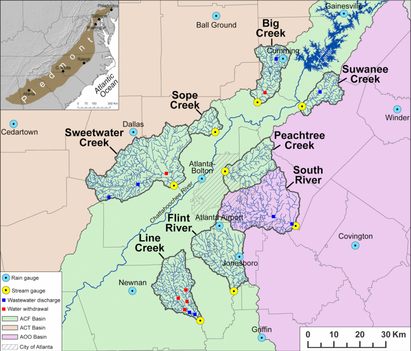
In the paper, published in the Journal of Hydrology , Georgia State Geosciences faculty examined trends in water flow over 30 years (from 1986 to 2015) in eight streams in the metropolitan Atlanta area: Big Creek, Flint River, Line Creek, Peachtree Creek, Sope Creek, South River, Suwanee Creek and Sweetwater Creek.
Of the eight, the Big Creek and Suwanee Creek watersheds—which are in the city’s booming northern suburbs—experienced the largest population increases. Both watersheds were among the three least densely populated in 1990, but by 2010 the population for Big Creek had nearly quadrupled, while Suwanee Creek’s population had tripled. Between 1992 and 2011, the amount of developed land in these watersheds also doubled, almost entirely at the expense of forest land.
In both watersheds, this urbanization led to a 26 percent increase in annual stream flow from 1986 to 2010, as well as a doubling of high-flow days.
“This means that during a storm event, you’ll now see more runoff, more extreme flows and more flooding than you would have seen for a similar storm event in 1986,” said Jeremy Diem, the study’s lead author and associate professor in the Department of Geosciences at Georgia State.
Urban development affects more than just stream volume, said Richard Milligan, co-author of the study and assistant professor of geosciences. “The increase in impervious surfaces—or surfaces that water can’t penetrate—also affects water quality, as the liquid runs over asphalt, picking up pollutants.”
Among the other rivers the researchers studied, the two least developed watersheds—Line Creek and Sweetwater Creek—had the lowest maximum stream flows, while the two most developed watersheds—Peachtree Creek and Sope Creek—had the highest. Researchers also found an extremely strong relationship between the amount of developed land and the average stream volume during high-flow days.
There were a few surprises, researchers said. The Peachtree Creek watershed, which was already highly developed before the 1986 start date of the study, experienced a decrease in annual stream flow. Diem and Mulligan hypothesize this is because of soil water leaking into the area’s aging sewage pipes, which direct it into a wastewater treatment facility.
“This is an area with older homes and buildings, which tends to mean older pipes with more cracks for water to infiltrate,” Diem said.

Urban river, Representative image, Source: Wikimedia Commons
Line Creek also experienced a drop in stream volume, despite the fact that the area saw a growth in development from 1986 to 2010. The researchers surmise this is the result of actively pumping water out of the stream. Line Creek was the only stream studied in which there were large increases in withdrawals for municipal consumption.
The South River experienced a larger-than-expected increase in annual stream flow and the number of high-flow days. The authors say this is likely because of a quirk in the way that water is distributed via utilities in the area. The water used to flush toilets or fill drinking glasses comes from the Chattahoochee River, yet after it’s treated the water is released into the South River, transferring the water from a basin flowing to the Gulf of Mexico to one that flows out to the Atlantic Ocean.
According to the Georgia Environmental Protection Division, an annual average of 37 million gallons per day is transferred out of the Chattahoochee and into South River in DeKalb County. By far the largest inter-basin transfer of water in Georgia, it is also the most contentious because of its implication in tristate water conflicts.
Georgia State graduate alumnus T. Chee Hill also contributed to the study.
Access paper 'Diverse multi-decadal changes in streamflow within a rapidly urbanizing region' HERE
Source: Georgia State University
Media
Taxonomy
- Integrated Urban Water Management
- River Studies
- Environment
- Flood Management
- River Engineering
- Urban Water
- River Basin management
- Urban Resource Management
- Flood management
- River Engineering
- flood protection