Water Column Offers Insight On Salt Marsh Carbon Cycle
Published on by Marcus Miller, Digital Marketing Manager at In-Situ
Water Column Offers Insight On Salt Marsh Carbon Cycle
Overview
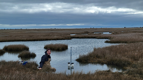
Researchers from Boston College collected continuous, baseline data in a New Jersey tidal marsh over a three-year period to better understand marsh contributions to the carbon cycle and how ponds and tidal channels function in the overall ecosystem metabolism of the marsh.
Challenge
Salt marshes are essential blue carbon ecosystems, storing large amounts of atmospheric carbon dioxide. Though they cover a relatively small area worldwide, they play a much larger role in the global carbon cycle than their size would suggest. Grass-covered marsh platforms in particular are known for their role as carbon sinks, but grasslands are just one part of a marsh ecosystem. Marshes also contain tidal creeks, shallow ponds, mud flats and open water, and there have been fewer studies documenting the role these other areas play in the carbon cycle.
Tidal marshes have always been vulnerable to sea level rise and tropical storms, but climate change is heightening and accelerating their toll on these environments. It’s more important than ever to gather baseline data on marsh environments, not only to better understand carbon cycling in the marsh, but also to establish a point of comparison to assess how these blue carbon ecosystems are affected by climate change.
Solution
The Cape May Wetlands in coastal New Jersey is an ideal area for long-term studies of tidal marsh habitats. The Wetlands Institute there has provided resources and support for organizations and scientists studying the marsh since the 1960s. Most recently, they’ve partnered with the U.S. Army Corps of Engineers (USACE), the USACE Engineer Research and Development Center (ERDC), and the State of New Jersey to create the Seven Mile Island Innovation Laboratory (SMIIL), building facilities to enable a variety of marsh research projects, including some focused on dredging monitoring and marsh restoration techniques.
In 2019, the ERDC established three open water platforms to support continuous water quality monitoring installations. The locations of the platforms provide an ideal vantage point from which to study the passage of water through the marsh–one at the entrance to the marsh channel, one centrally located and one where water from the marsh reenters open ocean.
John Supino, a PhD candidate studying chemical oceanography and wetland science at Boston College, has been working on research projects with The Wetlands Institute and its collaborators for several years. He and his research group saw an opportunity to use the new open water platforms to fill in some of the gaps in the current literature. Postdoctoral Researcher Emily Chua later joined the project, taking charge of the open water platform data, while John focused on data collected from nearby shallow ponds and a recent dredged sediment placement.
Data collection began in June of 2021, with two Aqua TROLL 600s installed at each of the three platforms to record depth, temperature, salinity, turbidity, dissolved oxygen, pH and chlorophyll a at different depths.
“The main thing we’re trying to study is how different water quality parameters covary in the water column,” Chua explains. The water column is one of the underexplored parts of the marsh’s carbon cycle, and Chua hypothesizes that local patterns in water quality may be influenced in large part by marsh metabolism rates as they relate to carbon cycling.
The Aqua TROLLs installed at the open water platforms recorded continuous data for three years–from June 2021 to June 2024–to provide a foundation of baseline data from which to analyze fluctuations in water quality throughout the water column. The instruments recorded data at 10-minute intervals; this high-resolution data allowed Chua and Supino to look at trends in the marsh’s metabolism from day to night as well as on seasonal and annual timescales.
Marsh deployments require rugged equipment that can withstand high levels of biogrowth. “Biofouling in the open ocean is going to be minimal compared to a marsh system because there’s just less stuff that makes its way out to the open ocean,” Supino explained. “So, instrumentation out there can be a bit more delicate, but we need a very reliable system for marsh monitoring. It has to be hardy.”
The USACE had been using the Aqua TROLLs to monitor dredging and marsh restoration techniques in the Cape May Wetlands for several years and recommended them for Chua and Supino’s project, citing their durability. “One of the nice things about an Aqua TROLL is you can throw it off a building and it still works,” Supino joked.
Supino traveled to the platforms regularly to download data from the Aqua TROLL 600s’ internal logs, cleaning the sensors about every six weeks. The instruments’ antifouling wiper kept the sensor faces clean between visits; without it, biogrowth would have made it necessary to visit and clean the sensors much more often, especially in summer when the marsh is most productive.
“Though the biofouling can be really bad, we back-test everything and the calibration stayed good the whole time,” Supino reports. “So, we have high confidence that what we're seeing is real.”
Results
Chua observed the trends she expected to see in the data; all three sites experienced...
READ MORE
Taxonomy
- Water Quality
- Habitat
- Wetlands
- Saline Water
- Water Monitoring
- Water Quality Monitoring
- Sea Level Rise Risk Perception
- Sea Level Rise Vulnerability Assesment
- Water Quality Monitoring
- Water quality
- Water Quality Research
- Water Quality Monitoring Sensor
- Water Quality
