Low-cost IoT-based System Developed to Forecast Floods
Published on by Water Network Research, Official research team of The Water Network in Technology
A team of researchers from Tokyo has developed a low-cost system to predict river flooding for developing countries, using "internet of things" technology.
 This technology will collect and analyze massive amounts of data from sensors placed along rivers.
Yosuke Tsuchiya, a researcher at the Tokyo graduate school, led the development of the system, which takes advantage of internet of things to form a network of numerous monitoring devices linked by the internet and processes data in a cloud-based system.
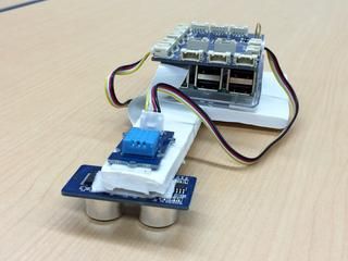
The system is based on a monitoring device with an ultrasound sensor that measures water levels, instruments to gauge temperature and humidity, and a camera, along with a low-cost Raspberry Pi microcomputer to process the data.
A large number of the devices will be placed at strategic locations along rivers, and data from them will be sent to the cloud-based system. Accessed via a computer, the data will be displayed on an on-screen map in real time.
The researchers worked with their counterparts at Universiti Brunei Darussalam, Brunei's national university, on a trial run of the system using a wired network in January. They plan to further develop it to find practical solutions for developing countries in tropical regions.
With its tropical climate, Brunei is prone to river floods, and damage often results from rains in upstream areas, affecting the many houses that are built over the river. The country does not have a weather information system that is easily accessible by citizens.
Tsuchiya hopes the system will prove particularly useful in countries like Brunei, which does not have an extensive weather monitoring and reporting system like Japan's. His team plans to try it in a number of countries in Asia and Africa.
The system compares current findings with past river levels, as well as precipitation data in the area, and outputs a percentage figure indicating the probability that the river will flood.
An alert is issued if the system decides the flood risk has reached a critical level, the researchers said.
Another key feature of the system is its function to accumulate data and manage it in a database, which it uses to determine for example, that a flood is likely occur when the water surface rises to a certain level.
The researchers believe they can also configure the system to come up with probability figures for the risk of landslides.
Read full article at: Nikkei Asian Review
Media
Taxonomy
- Technology
- Smart City
- Integrated Water Management
- Flood prediction
- Flood
- Internet
- Data Management
- Data