How the Barker and Addicks Dams Work
Published on by Water Network Research, Official research team of The Water Network in Technology
The destructive power of water in the wake of Hurricane Harvey leaves billions of dollars of devastation along the Gulf Coast while record-shattering rainfall is testing the Addicks and Barker reservoirs on Houston's west side.
Built by the federal government in the 1940s, before I-10 existed, before the city had sprawled that far west, these reservoirs remain essential to the region's flood control system, but they are little understood.
How do they work? What are they designed to withstand? I talked to Richard Long, the natural resources manager at the U.S. Army Corps of Engineers, to answer these questions.
How the dams work
The reservoirs are designed to connect Houston's watersheds and bayous that traverse across the region like the veins of a leaf and lead to Galveston Bay and the Gulf of Mexico.
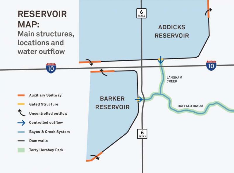
North of I-10 is Addicks Reservoir, fed by Bear Creek, South Mayde Creek, Langham Creek and Horsepen Creek. Water then flows outward to Langham Creek and Buffalo Bayou.
South of I-10 is Barker Reservoir, fed by Mason Creek and upper Buffalo Bayou from the Katy Prairie, its origin, and continues toward downtown.

Photo: Evan O'Neil
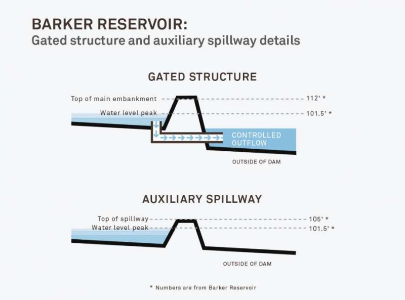
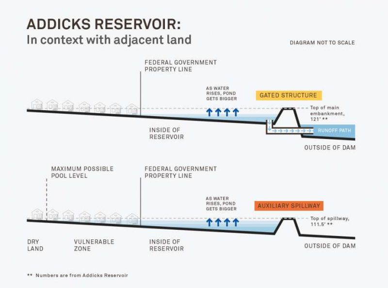
Long explained that the reservoirs have three main structural components. There are earthen embankments, which are the highest walls. The embankments are 121 feet high at Addicks and 112 feet at Barker.
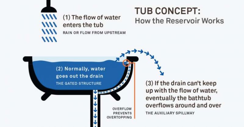
Each reservoir also has a "gated water control structure," or flood gate. It works like a heart valve, able to be opened and closed.
And each reservoir has two auxiliary spillways. The spillways at Addicks are 111.5 feet high, and they are 105 feet high at Barker. They are designed to back up the gated structures and work like the overflow holes in a sink, keeping water from going over the top or "overtopping" the embankments.
"We have designed the dams so that, in an extreme event larger than Harvey, water will go over the auxiliary spillway and never over the main embankment," he said. "The dams are prepared for events beyond what we are experiencing right now."

Photo: Evan O'Neil
Additionally, both Barker and Addicks, which are designed similarly but are not identical, are undergoing a maintenance project. Two new gated structures are expected to be completed by 2020 with Granite Construction Company as the contractor.
"We are building new water control structures adjacent to the current [ones]. They are under construction. They don't work yet," Long said. The existing gated structures will hold up longer, he said, but for how long is not known. Once the new structures are working, the old ones will be decommissioned.
The new gated structures will have current technology and standards. "[They] will have similar water control capability, but will be more robust, more repetitive and more resilient," Long said.
More robust, he explained, because they will be in an all-concrete tower with embedded steel; the old gated structures were lined with steel. More resilient because their conduits will be lined with steel to prevent deterioration. And more repetitive because the new structures will have two gates. If one fails, it would have a backup.
What they are designed to withstand
Now, normally, water is held behind the earthen embankments and flows through the gated structures into creeks and streams. The dams control flow into Buffalo Bayou, which keeps downtown Houston from flooding. Under normal, day-to-day conditions, and even during heavy rain events, the gated structure at Addicks releases water into Langham Creek and Buffalo Bayou; Barker releases into Buffalo Bayou.
But Harvey has not been a normal storm. The amount of rain that has fallen could fill the Astrodome 3,200 times, said meteorologist Jeff Lindner of the Harris County Flood Control District (HCFCD). So much rain has necessitated the high-volume controlled releases of water from the reservoirs over the next two weeks.
HCFCD officials said the reservoir levels peaked on Aug. 30, 2017, at 109 feet at Addicks and 101.5 at Barker. With the releases, the reservoir levels are dropping.
Once these high-volume controlled releases are over, normal releases will continue for about three months until the reservoirs are drained. These releases are designed to avoid a larger catastrophe and to empty the reservoirs in the event of another storm.
The Army Corps is now faced with deciding how to handle the competing demands of upstream development and downstream neighborhoods along the bayou.

Photo: Evan O'Neil
When overflow is activated at Addicks, it heads to Turkey Creek, Rummel Creek and possibly White Oak Bayou. At Barker, it would head to Buffalo Bayou, and possibly Brays Bayou and Oyster Creek. Barker also has two ditches, Barker and Clodine, surrounding it, acting as support arteries. They collect water outside the reservoir and carry it to the bayou.
Because Harvey has unleashed more than 50 inches of rain in a matter of days, the auxiliary spillways have had to come into use, Long explained. Inside Addicks, water is passing around the spillway. But not at Barker.
But once there is too much water on both sides of the dam, the flow is impacted. Further complicating matters, when channels like Buffalo Bayou fill up, water will look for all the other spaces it can fill up. And that is causing the serious issues that neighborhoods and homeowners are currently facing.
Thousands of people have been displaced from their homes near the reservoirs, as they were built on vulnerable property that lies in what Long calls "a gray area."

Photo: Evan O'Neil
Long explained that when the reservoirs were built, the federal government acquired a certain amount of land. At that time, the surrounding land was undeveloped. Historically, information sessions were conducted by the government as requested by private developers and homeowners. Public sessions were held when information was provided about the potential of water from the reservoirs encroaching on the surrounding land. But whether everyone who lives there now has been able to be fully informed is another matter.
"We can hold approximately a 100-year-flood within the boundaries of the government property," Long explained. "People have built on the land that is above the government property, but below the max possible pool level the dams can hold."
In short, the capacity of the dam is beyond the government property, and the Army Corps is handling a very complex emergency situation by controlling high-volume releases to protect the city as a whole.
"It has never flooded before above the property," Long said. "This is the first time we have flooded homes located adjacent to and upstream from the property."
If more water from upstream enters the reservoirs, the water level will continue to rise. If the inflow and outflow match, the water is level. If the inflow is less than the outflow, the water level will start to fall.
Source: Houston Chronicle
Media
Taxonomy
- Hydrology
- Flood Management
- Hydrogeology
- Dams
- Hydrology
- Flood management
- Flood Risk Management