Model Your Watershed with Free Online App
Published on by Water Network Research, Official research team of The Water Network in Technology
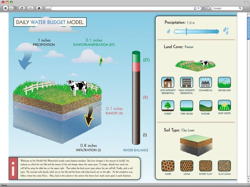
'Model My Watershed' is a web app that enables users to analyze real land use and soil data, model stormwater runoff and water-quality impacts compare different conservation scenarios.
A model 10 years in the making could make watershed protection decisions easier.
The application lets users analyze data, model storms and compare conservation and development scenarios in a watershed. It’s free to use, and users can predict things like how a new parking lot affects evapotranspiration, runoff and soil infiltration—or how using porous pavement for that same lot or adding an adjacent rain garden could mitigate those effects.
Users can define areas of study by congressional district, within one square kilometer, by drawing it freehand and other options. They choose from a number of map views. Selecting an area of study produces data including the land cover distribution, hydrologic soil distribution, estimated number of farm animals and discharge averages from point sources.
Then users can model a single storm or create a multi-year model, which looks at averages over 30 years.
Teachers and students are some of the app’s primary users.
“Students have used it when they wanted to propose a rain garden,” Kerlin said. Students use the model to determine how installing a rain garden would change the environmental impacts of the school’s land use, and then they do additional research on things such as how much the project might cost.
But students and teachers aren’t the app’s only users. The Model My Watershed team works farmers for larger scale projections, such as modeling the effects of a buffer of vegetation around nearby streams to filter nutrient runoff. Land use planners, water associations and state government agencies also benefit from the program.
The tool has been online for a few years but has gained more popularity recently. Kerlin estimates there are around 8,000 users at present, but he said it’s hard to track since not every user must register. The team continues to host seminars to spread the word.
Each month brings a new update, expanding the app’s features. Current funding will allow for 18 more months of updates.
Read more: Great Lakes Echo and Wiki Watershed
Media
Taxonomy
- Watershed Management
- Technology
- Integrated Water Management
- Watershed
- Integrated Watershed Management
- Watershed Management
- Mobile Apps
- Water Software