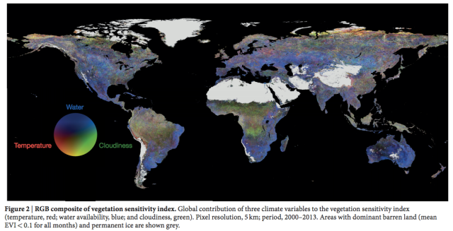
A map of the most vulnerable places on the planet
Published on by Naizam (Nai) Jaffer, Municipal Operations Manager (Water, Wastewater, Stormwater, Roads, & Parks) in Academic
Climate change isn't just one, uniform transformation of the planet. Over time, some areas are going to get hotter, some wetter, some cloudier—and vice versa. This map, produced using a new system for analyzing satellite data, reveals which parts of the planet will be most affected by these change s.
Published in Nature , the map above shows what the researchers call a vegetation sensitivity index (VSI). The VSI is a new measure of environmental vulnerability that combines several sources of data. The first source of data comes from the enhanced vegetation index—a measurement of plant cover on the ground year by year, built with data from a satellite-based, moderate-resolution imaging spectroradiometer.
The researchers combined this annual plant cover data with information about what would happen to the region if it experienced rapid fluctuations in temperature, moisture, and cloud cover.
Above, you can see a map showing which regions are sensitive to which kinds of fluctuations. Some areas suffer when water availability changes dramatically (becoming wetter or more arid); others suffer when cloud cover varies (become more cloudy or less cloudy).
When the researchers combined information about plant cover on the ground with those three climate variables, the result was the vegetation sensitivity index map you see at the top of this article. The researchers write in Nature :
"We find ecologically sensitive regions with amplified responses to climate variability in the Arctic tundra, parts of the boreal forest belt, the tropical rainforest, alpine regions worldwide, steppe and prairie regions of central Asia and North and South America, the Caatinga deciduous forest in eastern South America, and eastern areas of Australia."
It's crucial to keep in mind that these aren't areas whose ecosystems are on the verge of destruction, though some may be. Instead, they are areas with what the researchers call "lower resilience ... with a high probability of crossing a threshold to an alternative state." These kinds of areas are teetering on the edge of an environmental tipping point and are thus "more sensitive to environmental perturbations."
The researchers caution that some of the areas they identified as vulnerable, such as the steppe and the prairies, have never before been identified as having "threshold-type responses." The boreal forest and Arctic tundra, however, have long been known to be vulnerable to climate change. Also, as always with environmental studies, we need more data. This map is built from 14 years of data, and the more satellite data we get of global vegetation, the more accurate our predictions will be for which regions are vulnerable.
Attached link
http://arstechnica.com/science/2016/02/a-map-of-the-most-vulnerable-places-on-the-planet/Media
Taxonomy
- Environment
- Climate Change