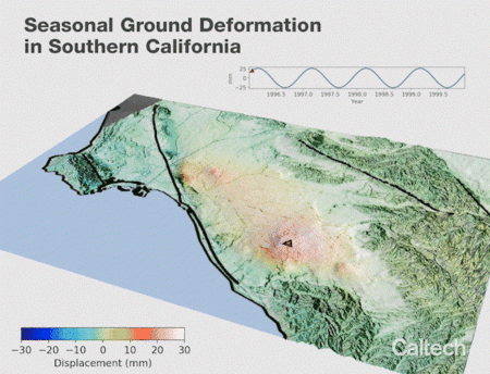
Animation Based on Satellite Data Shows SoCal "Breathing" Water
Published on by Water Network Research, Official research team of The Water Network in Technology
Using an unprecedented number of satellite radar images, geophysicists at Caltech have tracked how the ground in Southern California rises and falls as groundwater is pumped in and out of aquifers beneath the surface.
By Robert Perkins

Credit: Bryan Riel and Mark Simons; See animation HERE
Their findings are presented in a study that tracks deformation of the earth's surface over an 18-year period. The work can be used by water management districts to assess the precise shape and size of aquifers and the impact of the region's water use on those aquifers. The work also reveals what could be a previously unmapped fault running across northeast Orange County.
"What we see through the rising and falling of the ground surface is the elastic response of the land to regular changes in groundwater level," says lead author Bryan Riel (MS '14, PhD '17), who was a graduate student in the lab of Caltech's Mark Simons at the time of the research, and is now a signal analysis engineer at JPL, which is managed by Caltech for NASA. "Because we have data over a long period of time, we were also able to isolate long-term surface deformation signals, including subsidence of the land that seems to be caused by compaction of clay layers in response to background variations in groundwater withdrawal." Riel and Simons were also able to see sharp features where water was not flowing, which can indicate boundaries of aquifers as well as faults.
The study, which was published online on April 30 by the journal Water Resources Research, uses publicly available radar data captured between 1992 and 2011 by European Space Agency satellites. The satellite data was compiled into 881 radar interferograms—images created by bouncing radar signals off of the earth's surface—to track nearly vertical ground motion down to the millimeter with a horizontal resolution of tens of meters, over an area that stretches from San Fernando, northwest of downtown Los Angeles, down to Irvine, in Orange County.
When all of the images are stitched together, they show the ground beneath Southern California rising and falling annually, like a giant breathing in and out. The results were checked against GPS measurements taken by the Orange County Water District (OCWD) and the Water Replenishment District of Southern California, which corroborated the findings. The periodic rising and falling of the ground tells the story of the management of Southern California's aquifers and how that management has changed over time, says Simons, the John W. and Herberta M. Miles Professor of Geophysics at Caltech and JPL chief scientist.
"At the beginning of the study period, we see big sinusoids—higher highs and lower lows. Toward the later half of the study, that flattens out a bit, indicating that water control districts were more actively managing aquifers, and making sure to put water back into them instead of just taking it out," Simons says.
Roy Herndon, chief hydrogeologist for the OCWD, says that his team works to make sure that the ground never sinks too far—a development from which it might never recover.
"We suspect that the geology of our basin might allow subsidence to occur if we allowed too much groundwater to be pumped out but never refilled it. We have clays and silts that can compress and compact with time," Herndon says.
That strategy is codified in the Sustainable Groundwater Management Act (SGMA), signed into law by California Governor Jerry Brown in 2014, which dictates that groundwater managers need to avoid permanent lowering of the ground level. The phenomenon has plagued the San Joaquin Valley of Central California for generations. Soil compaction driven by a shrinking water table has caused the ground in the area to subside by as much as 28 feet, according to the United States Geological Survey (USGS). Herndon says that the study by Riel, Simons, and co-authors—and other surveys like it—will help water districts make sure that their water management strategies are effective at avoiding such soil compaction in California.
While the rising and falling of the ground was to be expected, the radar data also showed some unexpected features, Simons says, including a sharp boundary at the edge of an aquifer, which could indicate a buried fault along the eastern edge of a basin where the Santa Ana River passes through the Santa Ana/Garden Grove area. In addition, the map revealed a small area with anomalously large ground level uplift that turned out to be caused by petroleum operations pumping oil out and water in.
Riel, Simons, and co-authors relied upon data from ESA satellites. Meanwhile, JPL, NASA, and the Indian Space Research Organisation (ISRO) are planning to launch a new radar satellite called NISAR in early 2022 that will provide observations from two directions every 12 days—providing higher-quality, higher-resolution data than have previously been available.
"With that kind of data, we'll be able to paint an even clearer picture that could reveal even more about the ground beneath our feet," Simons says.
The study is titled "Quantifying Ground Deformation in the Los Angeles and Santa Ana Coastal Basins Due to Groundwater Withdrawal." Other co-authors include Daniel Ponti of the USGS; JPL's Piyush Agram, who is a visiting associate at Caltech; and Romain Jolivet of the École Normale Supérieure in Paris, France. Support for this research came from NASA.
Read full article: Caltech
Media
Taxonomy
- Software & Modelling
- Modelling
- Modeling
- GIS & Remote Sensing Technology
- Hydrology
- Hydrography
- GIS
- Hydrological Modelling
- GIS for network
- Groundwater Modeling
- Hydrologist
- 3D Modelling
- GIS & Remote Sensing
- Modeling Tools