Flood Damages in Europe to Increase
Published on by Water Network Research, Official research team of The Water Network in Academic
The researchers presented their results at this year'sEuropean Geosciences Union (EGU) conferencein Vienna
Flood damages across Europe as the climate warms are likely to be considerably higher than previously thought, according to new research.
Without efforts to reduce emissions, extreme river floods now occurring every 100 years will become twice as likely in the next three decades, according to scientists from the European Commission's Joint Research Centre.
That means we can expect climate-related damages to land, property and people across Europe to increase by an average of 200% by century-end, say the authors.
The researchers presented their results at this year'sEuropean Geosciences Union (EGU) conferencein Vienna earlier today.
New and improved
At current emissions rates, limiting global average temperature rise to 2C looks increasingly unlikely, lead authorDr Lorenzo Alfieritold a press conference this morning. That means there is a need for scientists to assess the impacts ofhigher levels of warming, he said.
The researchers examined how flood risk in Europe is likely to change under the Intergovernmental Panel on Climate Change (IPCC)'s highest emissions scenario, RCP8.5. This scenario projects 5 to 6C of warming above pre-industrial temperatures by 2100.
The new research makes a number of technical advances that improve the reliability of flood projections compared to previous studies, say the authors.
The researchers combine regional climate projections under the IPCC's high emissions scenario with a complex simulation of the water cycle. This captures how quickly water disperses after falling as rain and how it cycles through terrain, soil, vegetation, the atmosphere, rivers and oceans.
The study adds in maps of the areas in Europe most vulnerable to flooding in terms of land use and population density, as well as the existence of flood defences. This gives an estimate of the overall flood risk from European rivers breaching their banks this century.
Flood waters rising
The model results show that of 22 large European river catchments, nine see an increase in the total average annual rainfall by 2080. These are mostly located in northern and Eastern Europe, with the largest changes in Iceland and Scandinavia (blue areas in the left map below). In seven southern European regions, annual average rainfall decreases (red areas).
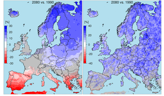
Change in average annual precipitation in 22 European regions containing large rivers by 2080. Change in annual maximum daily precipitation (right). All figures are relative to the average for the baseline period of 1976 to 2005 (midpoint 1990). Source: Alfieri et al., (2015)
Damage done
Overall, the new research projects that the amount of water flowing in large European rivers will increase in 73% of the study area by 2080. This is shown by the blue lines in the map below. Taking into account the size of the rivers and the projected changes, this corresponds to an average increase in water flow of 8% by 2080 compared with 1990.
The authors conclude that changes to rainfall and streamflow mean that across Europe, extreme floods are likely to double in frequency within the next three decades. For example, floods that used to happen about every 100 years will start to occur every 50 years instead.
Source: The Carbon Brief
Read More Related Content On This Topic - Click Here
Media
Taxonomy
- Research
- Environment
- Flood Management