Houston's Flood Is a Design Problem
Published on by Water Network Research, Official research team of The Water Network in Academic
It’s not because the water comes in. It’s because it is forced to leave again.
BY IAN BOGOST
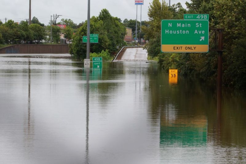
Image source: The Atlantic
Floods cause greater property damage and more deaths than tornadoes or hurricanes. And Houston’s flood is truly a disaster of biblical proportions: The sky unloaded 9 trillion gallons of water on the city within two days, and much more might fall before Harvey dissipates, producing as much as 60 inches of rain.
But the impact of flooding, particularly in densely developed areas like cities, is far more constant than a massive, natural disaster like Harvey exposes. The reason cities flood isn’t because the water comes in, not exactly. It’s because the pavement of civilization forces the water to get back out again.
The natural system is very good at accepting rainfall. But when water hits pavement, it creates runoff immediately. That water has to go somewhere. So it flows wherever the grade takes it. To account for that runoff, people engineer systems to move the water away from where it is originally deposited, or to house it in situ, or even to reuse it.
This process—the policy, planning, engineering, implementation, and maintenance of urban water systems—is called stormwater management.
According to my Georgia Institute of Technology colleague Bruce Stiftel, who is chair of the school of city and regional planning and an expert in environmental and water policy governance, stormwater management usually entails channeling water away from impervious surfaces and the structures built atop them.
In other words, cities are built on the assumption that the water that would have been absorbed back into the land they occupy can be transported away instead.
Like bridges or skyscrapers designed to bear certain loads, stormwater management systems are conceived within the limits of expected behavior—such as rainfall or riverbank overrun events that might happen every 10 or 25 years. When these intervals are exceeded, and the infrastructure can’t handle the rate and volume of water, flooding is the result.
Houston poses both a typical and an unusual situation for stormwater management. The city is enormous, stretching out over 600 square miles. It’s an epitome of the urban sprawl characterized by American exurbanism, where available land made development easy at the edges. Unlike New Orleans, Houston is well above sea level, so flooding risk from storm surge inundation is low. Instead, it’s rainfall that poses the biggest threat.
A series of slow-moving rivers, called bayous, provide natural drainage for the area. To account for the certainty of flooding, Houston has built drainage channels, sewers, outfalls, on- and off-road ditches, and detention ponds to hold or move water away from local areas. When they fill, the roadways provide overrun.
The dramatic images from Houston that show wide, interstate freeways transformed into rivers look like the cause of the disaster, but they are also its solution, if not an ideal one. This is also why evacuating Houston, a metropolitan area of 6.5 million people, would have been a terrible idea.
This is a city run by cars, and sending its residents to sit in gridlock on the thoroughfares and freeways designed to become rivers during flooding would have doomed them to death by water.
Read full article: The Atlantic
Media
Taxonomy
- Urban Drainage
- Flood Management
- Urban Water
- Urban Drainage System
- Urban Water Infrastructure
- Flood management
- Flood damage
- Flood prediction
- Flood Risk Management