Mapping Floods Before They Happen
Published on by Marina A, Previously Key Account and Content Manager at AquaSPE AG in Technology
GIS can be used for mapping flood-prone areas, as a way of predicting floods, their impact and to mitigate their effect as much as possible.
Flood prediction and mitigation have an impactful importance and are crucial in helping communities.
Flood maps created without using GIS are not as reliable and are created based on the forecast and the expected amount of rain. Such maps do not include the terrain topography and are only valuable for smaller areas.
Geographic Information System (GIS) is a software for capturing, storing, handling, processing and analyzing special and geographic data.
Remote sensing and GIS have transformed flood prediction and monitoring.
Using GIS improves the flood prediction maps as it adds additional parameters crucial for better-accuracy calculations.
Maps of floods before they happen are made based on expected precipitation and terrain analysis – elevation in comparison to the highest predicted river level.
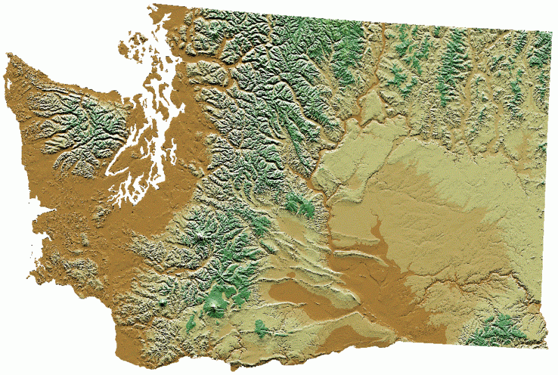
Image: Digital elevation model for Washington
To make flood predictions, scientists use a spatial analysis software (GIS) to combine and analyze the digital elevation models and computer-made flow models.
Terrain data is gathered by Light Detection And Ranging (LIDAR) technologies which are fast and accurate and provide accurate elevation levels of an area. LIDAR is used to quickly gather data from large areas using an airplane and GPS.
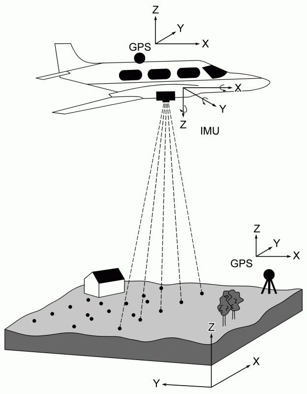
Image: Light Detection And Ranging (LIDAR) technology application
Computer models are used to predict the physics of the fluid flow, based on complex equations. The number of equations significantly grows with the size of the area so the analyzed region is limited by the equations.
GIS is a database which processes terrain information and fluid flow models to create flood maps based on calculations of available data.
Sources:
Media
Taxonomy
- Modeling
- GIS & Remote Sensing Technology
- GIS
- Flood Modeling
- Flood prediction
- Flood Risk Management
- GIS & Remote Sensing
4 Comments
-
This would be helpful in knowing where to evacuate, such as in S California floods after the fires.
-
How to use this?
-
I am sure technology is accurate to a point. But I do not see the logic of desiring to know "How much" water from a flood so you can prepare to deal with the damages. It would be better to work with nature. Large construction projects can be avoided but increasing the inline storage of flood waters. If for Example you have a designated flood level and the amount over this causes flooding. That amount can be measured. 10 year, 50 year, 100 year flood records. The decide how to expand the tributaries, rivers, lakes capacity to handle more flood waters to reduce and ultimately eliminate flooding. Dredging, deeper channels, eliminate small islands/sandbars in the middle of a river. The easiest and least expensive is to create new flood relief tributaries that lead into a (your decided size) lake/ reservoir One or equal sizes at equidistance as needed. best part is if flooding level increase. Simple to add one more to your inline system. (when the work gets too hard you do not get a bigger OX. You get more OXEN).
1 Comment reply
-
Dear Suraj, greetings. Respectfully, I think you missed the point of the application of remote sensing and GIS technology to assessment of the estimated extent of floods of different magnitudes. It is a great "first cut" analysis that then can facilitate the planning of infrastructure to contain floods. There is no conflict between both steps in the engineering approach. Traditionally hydraulic engineers would do this first cut with topographic maps where traditional hydraulic equations would be applied to obtain a first cut estimate of the area that would be flooded by a rain of certain frequency and magnitude. This was a trial and error procedure since most topo maps have significant elevation errors. We now have the marvel of the computers and different hydraulic models that can be linked to a GIS system to do the same analysis a lot more accurate, much quicker and at a much lower cost. Still, the final design of water works to control, manage and contain floods must be based on field surveying and planning as you discussed. GIS is only one more tool in our toolbox for the management and wise development of basins.
-
-
Development of flood maps with remote sensing and GIS terrain applications is just an approximation that cannot be used effectively for regulating construction and development in basins. There are many features in a basin that constrict or expand flow, such as culverts and bridges, whose dimensions can only be obtained from field surveys. The LIDAR techniques do not have the sensitivity required to properly assess the geometry of these structures. Flood maps also are related to the rugosity of the terrain and channel. This is a varying factor in a basin that only the eye of the experienced hydrologist can estimate in the field with multiple photographs and visual calibration against tables developed in prior times. I am a fan and user of ARCGIS, and favor using it to develop an initial assessment of the potential extent of a floods in a basin, but not for regulatory or development purposes. Field derived maps are required for those activities.
2 Comment replies
-
Hi, Marina. I think that the GIS approach is a great tool for reconnaissance studies prior to the field work needed to develop relatively accurate flood maps that can be used for planning, regulating and design activities in a basin. Perhaps my perspective is related to living in USA where FEMA (Federal Emergency Management Administration) flood maps are required in essentially all communities for management of flood plains. I can see the tool being applied in countries now developing as a "first cut" to make general decisions on developments. But then this initial interpretations need to be validated with field surveys of historical floods.
-
Dear Ferdinand Quinones ,
Thank you for your feedback. I was coming from a perspective that if a lot of precipitation is expected in a certain location, rapid measures, plans and decisions need to be made. Hence, sending experienced hydrologists is not always the best and most viable option.
I, and other members of The Water Network, would appreciate your input and experience. Please feel free to post an Article or a Blog on similar topics so we can all learn something new.Regards,
Marina
-