Mauritius Water Authority uses GIS to Map Assets and Modernise System - Esri South Africa
Published on by Water Network Research, Official research team of The Water Network in Case Studies
 In Mauritius, an island nation located off the coast of Africa, the Central Water Authority (CWA) serves nearly 400,000 customers . The goal of the water authority is to ensure a sustainable water supply that supports the country’s economic development. The water authority lacked a standard, centralised database of its distribution network, which consisted of paper-based systems. Maps and technical information had to be processed, printed, and then dispatched by smartphones to different CWA offices around the island.
The Challenge
About ten (10) years ago, the often outdated paper-based systems and CAD drawings had led to slower processes and department employees were working in silos, which made it challenging to have concise, accurate information promptly. The IT department and the drawing office were not sharing information, making data gathering cumbersome. Moreover, they were not managing real-time asset information to address customer complaints effectively.
The water authority began implementing geographic information system (GIS) technology across its departments and customer service operations to support real-time data collection. The full implementation of GIS took years due to the lack of funding and resources available to the CWA. In 1999, the CWA implemented a GIS project for pipe reticulation but paused acquiring orthophotos due to contract and financing challenges. Eventually, in 2008, the CWA resolved setbacks with the orthophoto acquisition and proceeded with a complete GIS mapping and database project.
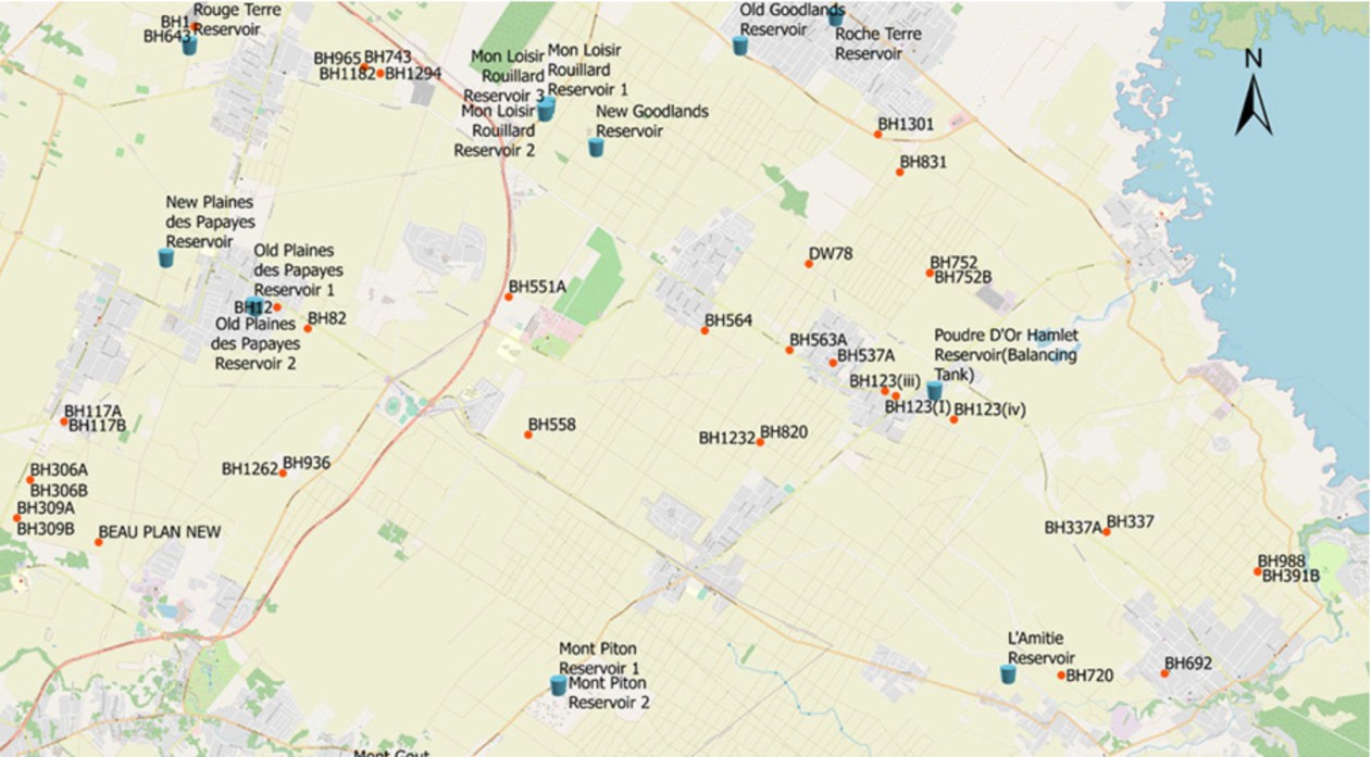
Map showing Reservoirs & Boreholes with names containing all details in attributes. All reservoirs have details including size, capacity, source of water, the region served, materials constructed and top water level, amongst others. Source: Esri South Africa
The Solution
Senior officials at the CWA pushed for implementing GIS in mapping the water distribution system. GIS displays dashboards and maps to make information faster to process for all stakeholders involved in water distribution throughout the country.
“Very few government organisations in Mauritius are using GIS, but we have been able to make rapid progress due to the capabilities in GIS and share information quickly,” said Veemul Gopaul, senior technical design officer, drawing office, CWA.
The new GIS maps enable an application to pinpoint the client’s location when complaints are logged and send a message to the regional field maintenance department. Previously, complaints were logged through phone calls and emails, sometimes resulting in inaccurate instructions to mobile staff. Now, a single step saves time and effort.
In addition to helping residential customers, the CWA uses GIS to create accurate maps of water asset locations, including the CWA’s pipe network and water distribution appurtenances. Currently, 95% of the CWA network is mapped, with plans to continue to add data. These maps display boreholes, reservoirs, and impoundments over base maps of the region. “Due to the ease of having visual information, GIS easily provides visual support in terms of dynamic maps that tell us the behaviour of water networks and our customers,” said Gopaul.
The Result
The addition of GIS to the water authority has made the workflows more efficient in the past 18 months, and other government agencies are noticing. “Management has appreciated visual maps and pipe information [such as] length, age, and material. [Staff] are accustomed to viewing this information on spreadsheets, which limits their ability to visualise data over time or with precision,” said Gopaul.
The creation of the GIS database has empowered CWA with interactive maps that facilitate easy editing with additional data layers, enabling more thorough analysis and faster decision-making. Moving forward, the CWA aims to advance its complaint system. Developed by individuals without a GIS background who learned to utilise the technology, the system now streamlines processes from dispatch to operations, facilitating quicker problem resolution, which translates to time and cost savings for the water authority.
This article has been republished from Esri, South Africa. For further details on this project and related case studies showcasing the use of GIS technology to map assets and transform systems throughout Africa, please refer to the provided link .
Taxonomy
- GIS & Remote Sensing Technology
- GIS
- GIS Spatial Analysis
- GIS & Remote Sensing
- Satellite
- 3D GIS
1 Comment
-
Our low- cost sustainable easy to maintain nutrient process is ideal for off grid communities to produce their own fertiliser from waste and leave clean agricultural water.