Research Finds Discrepancies Between Satellite and Global Model Estimates of Land Water Storage
Published on by Water Network Research, Official research team of The Water Network in Academic
Research led by The University of Texas at Austin has found that calculations of water storage in many river basins from commonly used global computer models differ markedly from independent storage estimates from GRACE satellites.
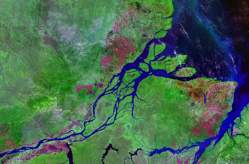
Satellite image of mouths of Amazon River in Brazil. Source: Wikimedia Commons
The findings, published in the Proceedings of the National Academy of Sciences on Jan. 22, raise questions about global models that have been used in recent years to help assess water resources and potentially influence management decisions.
The study used measurements from GRACE satellites from 2002 to 2014 to determine water storage changes in 186 river basins around the world and compared the results with simulations made by seven commonly used models.
The GRACE satellites, operated by NASA and the German Aerospace Center, measure changes in the force of gravity across the Earth, a value influenced by changes in water storage in an area. The computer models used by government agencies and universities were developed to assess historical and/or scenario-based fluxes in the hydrological cycle, such as stream flow, evapotranspiration and storage changes, including soil moisture and groundwater.
“People are depending more and more on global models to determine projections of the impacts of human water use and climate on water resources,” said lead author Bridget Scanlon, a senior research scientist at the university’s Bureau of Economic Geology. “We are now able to evaluate water storage changes from models with GRACE data, which suggests that the models may underestimate large water storage changes, both large declining and rising storage trends.”
For example, in the Amazon River basin, GRACE data indicate that water storage increased by 41 to 43 cubic kilometers during the study period — the largest increase in water storage of any basin in the world. But most of the models projected huge declines in water storage, with one simulating a loss of 70 cubic kilometers. The model that most closely matched the GRACE data calculated an increase of only 11 cubic kilometers.
In the Ganges River basin, GRACE showed a loss of 12 to 17 cubic kilometers of water per year over the 12-year period — the biggest decrease in water storage measured by the study. The models range between a loss of 7 cubic kilometers and an increase of 7 cubic kilometers.
Overall, the model results calculated a decline in global water storage during the study period, while GRACE data indicate it was on the rise. However, the study notes that while the climate increased water storage globally, humans caused significant declines in certain regions. The study area covered about 63 percent of global land area and excluded Greenland and Antarctica because most of the water in those areas is trapped in glaciers or ice sheets.
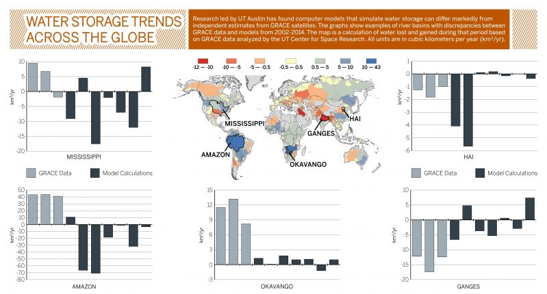
A graphic comparing water storage estimates from GRACE satellites and computer models. Note the differences in the scale bars of each graph. Complete comparison data available in study by Scanlon et al, 2018. The University of Texas at Austin Jackson School of Geosciences.
The study shows that there are regions where global models need to be improved, said co-author Hannes Müller Schmied, a senior research scientist at Goethe University Frankfurt. The global perspective of the research can help scientists understand why models are performing better in some areas than others, and zero-in on the areas where they’re not matching up with the data.
Read full article: The University of Texas at Austin
Media
Taxonomy
- Resource Management
- Water Resource Management
- GIS & Remote Sensing Technology
- GIS
- River Studies
- River Engineering
- Water Resource Management
- Groundwater Quality & Quantity
- Remote Monitoring & Control
- GIS & Remote Sensing