Satellites and Cell Phones Form a Cholera Early-Warning System
Published on by Water Network Research, Official research team of The Water Network in Technology
A new initiative combines satellite data with ground observations to assess and predict the risk of cholera outbreaks in Bangladesh’s vulnerable populations.
Cholera, an acute waterborne diarrheal illness, poses a major threat to global health, especially in developing countries of sub-Saharan Africa and South Asia. Estimates suggest that cholera affects approximately 2.9 million people each year across the 69 countries in which it is endemic, and it causes an estimated 100,000 deaths annually [Ali et al., 2015].
A multidisciplinary team of scientists from the United States is working with the International Centre for Diarrhoeal Disease Research, Bangladesh (ICDDR,B) and Bangladesh’s North South University to address these critical problems of prediction, preparation, and prevention. The team’s new initiative combines satellite remote sensing data with ground observations to assess and predict the risk of cholera outbreaks in vulnerable populations of the country.
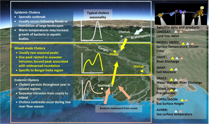
Fig. 1. A constellation of NASA satellites provides Earth observation data for assimilation into a cholera early-warning framework for Bangladesh. Triangles correspond to the type of cholera monitored using each satellite’s data. Via: EOS
Forecasting a Cholera Outbreak from Space
To develop forecasts of the risk of a cholera outbreak across Bangladesh, the team monitors regional hydroclimatic processes and changes in the natural aquatic ecosystem with near-real-time Earth observations (EO) obtained from a constellation of NASA satellites (Figure 1). It incorporates precipitation data from the Tropical Rainfall Measuring Mission satellite and its successor, the Global Precipitation Measurement mission (TRMM-GPM); air temperatures from the Moderate Resolution Imaging Spectroradiometer (MODIS) instrument; and water storage information from the Gravity Recovery and Climate Experiment (GRACE) satellites.
These data, along with data from other sensors and hospital and socioeconomic data, are used to assess the hydroclimatological risk of cholera in the study region [Jutla et al., 2015b]. Project findings and results are being used to map unsafe water sources, prepare warnings related to water quality, and predict the potential of natural disasters.
The project findings assist in filling critical information gaps on what, when, and where levels of risks exist and which preventive measures should be taken to deal with problems of unsafe water and sanitation access during critical seasons of the year. To determine the breadth of issues in the environment, the team is implementing a pilot project in two remote locations inside Bangladesh—one coastal and one inland—that represent contrasting underlying processes. The ongoing project generates awareness among vulnerable populations and local public health departments.
Read full article: EOS
Media
Taxonomy
- Public Health
- GIS & Remote Sensing Technology
- GIS
- GIS for network
- GIS Spatial Analysis
- GIS & Remote Sensing
- Water Sanitation & Hygiene (WASH)