Scientists Monitor Silicon Valley’s Underground Water Reserves - From Space
Published on by Water Network Research, Official research team of The Water Network in Academic
Scientists have used satellite data to monitor underground water reserves in California’s Silicon Valley, discovering that water levels rebounded quickly after a severe drought that lasted from 2012-15.
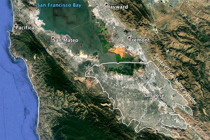
This Google Earth image shows the boundaries of the Santa Clara Valley aquifer. The aquifer is an important source of water for California's Silicon Valley, including the city of San Jose. Image: Google Earth, Source: UBNOw
The research points to the success of aggressive conservation measures. It also helps to lay the groundwork for low-cost monitoring of subterranean water reserves in California and elsewhere in the world.
Underground stockpiles of water — housed in layers of porous rock called aquifers — are one of the world’s most important sources of drinking water. They sustain human populations in places from Silicon Valley to Beijing. Some 2.5 billion people on Earth rely on aquifers for water, and many of these repositories are being drained more quickly than they can be refilled, according to the United Nations Educational, Scientific and Cultural Organization.
Yet, keeping tabs on these precious reserves is expensive, says Estelle Chaussard, assistant professor of geology in UB’s College of Arts and Sciences, and the lead author of the new research.
“To monitor aquifers, you have to monitor water levels in as many wells as possible,” she says. “So if you have 300 wells in the area, you have to either have someone who physically goes there all the time, or instruments in each well that monitor permanently, which is very costly.
“We wanted to see if we could use a low-cost, remote-sensing method that doesn’t require ground monitoring to understand how our aquifers are responding to a changing climate and human activity.”
The research was published Sept. 22 in the Journal of Geophysical Research. The team included Pietro Milillo and Eric J. Fielding from NASA’s Jet Propulsion Laboratory; Roland Bürgmann from the University of California, Berkeley; Daniele Perissin from Purdue University; and Brett Baker from the Santa Clara Valley Water District.
Measuring tiny movements of Earth’s surface
Chaussard’s team used a technique called InSAR — Interferometric Synthetic Aperture Radar — to capture the tiny up-and-down movements of the Earth’s surface that occur when water levels rise or fall underground.
“InSAR allows us to precisely measure small movements of the Earth’s surface over large areas,” Chaussard says. “Scientists have used it to measure surface deformation related to volcanoes and earthquakes; we expanded its use by applying it to tracking groundwater.”
She first employed InSAR to monitor aquifers in 2014, and says the method can work anywhere in the world where satellite data is available, including in developing nations with few resources for monitoring.
The technique marks an improvement over traditional methods because it allows scientists to gauge changes in water levels across a large region with great frequency. The data in the new study came from COSMO SkyMed, a constellation of four Italian satellites that provided information for the entire Santa Clara Valley aquifer as often as once a day.
Read full article: UB Now
Media
Taxonomy
- Resource Management
- Water Resource Management
- Groundwater
- GIS
- Hydrology
- Groundwater Recharge
- Groundwater Mapping
- Hydrologist
- Hydrology Cycle
- GIS & Remote Sensing