The Evolution of Earth Observation: How Technology Helps Identify Risk of Pollution
Published on by Water Network Research, Official research team of The Water Network in Technology
For the Ingenia online magazine, science writer Tereza Pultarova spoke to companies that are using the data to solve problems on Earth and how artificial intelligence is helping them to do that more quickly.
One of her correspondents is Philip Briscoe, Chief Operating Officer of geospatial data analytics company Rezatec that helps water utilities identify the risk of pollution from agricultural land use.
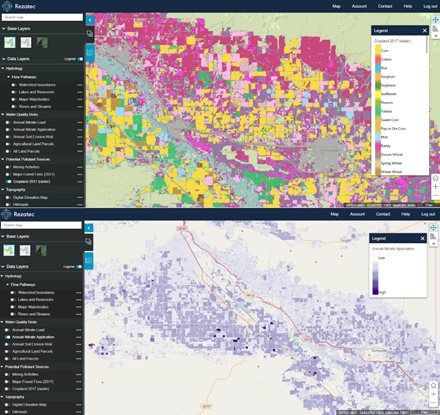
The top image shows the automation of crop identification through the interpretation of satellite data (radar and optical) using machine learning techniques. Engineers feed vast volumes of data into Rezatec’s crop ID model to train it to recognize the ‘signature’ of specific crops with over 97% accuracy. The bottom image shows estimates of nitrate application volume based on crop type and application of fertilizers, which is then fed into the model to map risk to water sources, such as rivers and reservoirs, to support catchment management activity. Image by Rezatec (image source: Ingenia)
Briscoe says that customers’ interest increases as soon as they see how easy it is to solve their problems with intelligence derived from satellite images. For example, one of Rezatec’s projects was a collaboration with Portsmouth Water, which had witnessed rising nitrate levels in groundwater for some years and wanted to understand more about the sources of this pollution. Removing the contaminants and making the water fit for human consumption needed a complex and costly treatment process, and the water company hoped that discovering the source of the problem would solve the situation much more efficiently.
Portsmouth Water was not only interested in land management related to farming but also that related to equine use, for example horse paddocks and manure heaps, which can all produce varying localised sources of nitrate pollution. Rezatec initially used its crop identification and land use algorithms to interpret satellite data to produce an interactive map. Using modelling techniques to analyse the topography and hydrology of the area, the likely overland flow of nutrients and pesticides that impact pollution was mapped, along with overland flow paths and sinkholes that allow nitrate pollution to enter the groundwater.
It knew that the area that Portsmouth Water operates on is situated on chalk land, which meant that it was very easy for surface water to penetrate into groundwater. While there was nitrate from equine activity, the problem was exacerbated by the volume of sinkholes in the ground that were leaching nitrates from agricultural activities: rain was washing away pesticides and fertilisers that farmers were using on crops. Using the satellite data, Rezatec could identify which fields were causing the problem and enable Portsmouth Water to interact with landowners to help protect the water resources.
Building on this, Rezatec extended its services to water utility companies by looking at pipeline leakage risk and how to enable more proactive and efficient asset management. This service begins by feeding various types of data into Rezatec’s geospatial analytical engine. This includes weather data, soil maps, satellite data and information about the state of the infrastructure and past incidents provided by the water utility companies. Rezatec then uses machine learning to build an understanding of the conditions under which failures occur. Observations of ground conditions are continually monitored to quantify likelihood of failure across the network. Pipelines at most risk of leakage are highlighted for proactive monitoring and then Internet of Things sensor activity can be fed into the service to pinpoint issues early.
Briscoe says that its pipeline leakage risk service enables water utilities to use their manpower more efficiently and reduce capital expenditure costs such as acoustic loggers; instead of sending ground crews to investigate the entire network at regular intervals, the engineers only go and visit those locations or install loggers where there is a high risk of leakage identified by the system.
"The evolution of Earth observation" article by Tereza Pultarova is published on Ingenia Online
Media
Taxonomy
- GIS & Remote Sensing Technology
- GIS
- GIS for network
- Water
- Information Systems
- Agriculture
- Technologies
- Software & Services
- Water Software
- IT Managment
- Database Managment
- Security
- Watermarking
- Surveillance
- Monitoring Technology
- Remote Monitoring & Control
- Sensorial networks
- GIS & Remote Sensing
- Internet of Things (IoT)
- AI
- application of GIS and RS
- artificial intelligence
- GIS Manager
- Smart Water Monitoring
1 Comment
-
The elephant in the room is (the cumulative effects of) Marine Outfall discharge (readily observed, poorly monitored and generally ignored), which must cease if we expect to prosper as a global community. After all, Sustain-Inability begins with Pollution, for which "Every" Business and Community worldwide does so well!