The Robots, Sensors and Satellites Digitizing the Ocean
Published on by Water Network Research, Official research team of The Water Network in Technology
The nascent Digital Ocean movement aims to provide real-time information on climate change, fisheries and other marine conditions by using mobile technology to link autonomous vehicles, ships and sensors to shore.
Real-time data for oceans data is lacking.
That’s beginning to change as scientists, governments and the private sector seek to collect more data from the ocean for climate change research, security, resource extraction and other purposes.
Liquid Robotics, a Silicon Valley-based company that manufactures an autonomous sea-faring robot called the Wave Glider, dubs it the “Digital Ocean” – an effort to build a vast network of remote, relatively low-cost instruments at sea that are capable of communicating with one another and with satellites, airborne drones and onshore facilities
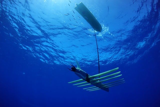
Liquid Robotics sees its autonomous, wave-and-solar-powered Wave Glider as a router in a digital ocean.
Courtsey of Liquid Robotics, a Boeing Company
Powering itself with wave energy and solar panels, the Wave Glider can carry a sensor payload to collect data, sampling to a depth of 30ft (9m). That’s a very active zone biologically, but it comprises less than 1 percent of the ocean.
Perhaps the Wave Glider’s most significant role in the Digital Ocean is therefore similar to that of a network router. Radio waves don’t travel well through water, and acoustic telemetry can’t carry much data.
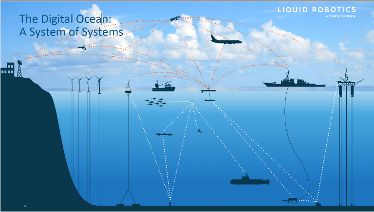
The infrastructure of the Digital Ocean. ( Courtnesy of Liquid Robotics, a Boeing Company)
The Wave Glider links systems that use different modes of communication: Sensors on the seafloor can transmit data on tectonic activity acoustically to a Wave Glider on the surface, which beams to shore via satellite or cellular connection. Such a system, for instance, could form the basis for a tsunami detection system.
Liquid Robotics unveiled the next generation of the Wave Glider, which is capable of operating in more extreme ocean conditions and can carry heavier payloads and operate longer at sea on a battery with 40 percent more storage.
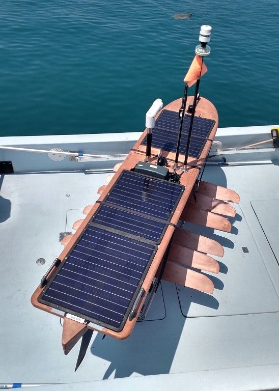
The next-generation Wave Glider. (Liquid Robotics)
Organizations such as the Ocean Tracking Network (OTN) and UNESCO’s Global Ocean Observing System have been leaders in deploying remote sensing equipment to build a global telemetry capability.
OTN, housed at Dalhousie University in Halifax, Nova Scotia, has for years deployed various forms of telemetry, including biologging, where a tracking device is placed on the back of a marine animal. It carries onboard sensors that determine the length of the day, which allows for calculation of latitude and longitude; pressure, which tells how deep the animal is underwater; and water temperature. But that’s only useful if the animal is later recovered. A second class of sensor emits a sonic ping that’s picked up when the animal passes within range of a receiver, either a stationary one or a vehicle such as a Wave Glider. The newest development in fish tags is one that dislodges itself as its battery is about to run out, pops to the surface, and transmits all the data it has collected to a satellite.
The organization also deploys Wave Gliders and a submersible autonomous vehicle called a Slocum. “You tell it to record temperature, depth, salinity,” Whoriskey said. “We’re working on acidification sensors, gas sensors for carbon – whatever you’d like to include and it will tell you what’s going on at various depths. That’s a gold mine of information about the structure of the water column.”
He pointed to weather forecasting and marine safety as other areas that will benefit from the development of the Digital Ocean. “With more data, insurance companies and developers can take preventive measures and policymakers can impose conditions on what’s being built and make it ready for the climate we’re going to have to survive in,” he said.
Source: Oceans Deeply
Media
Taxonomy
- Environment
- Environment Evaluation
- Oceanographic Survey
- Satellite
- Data
- Data & Analysis