USGS Crews Measure Record Flooding in South-Central Texas
Published on by Water Network Research, Official research team of The Water Network in Academic
U.S. Geological Survey field crews are measuring record flooding in parts of south-central Texas following intense rainfall from Tropical Storm Harvey.
57 USGS streamgages are over National Weather Service flood levels, and water continues to rise at 118 gauges throughout Texas.
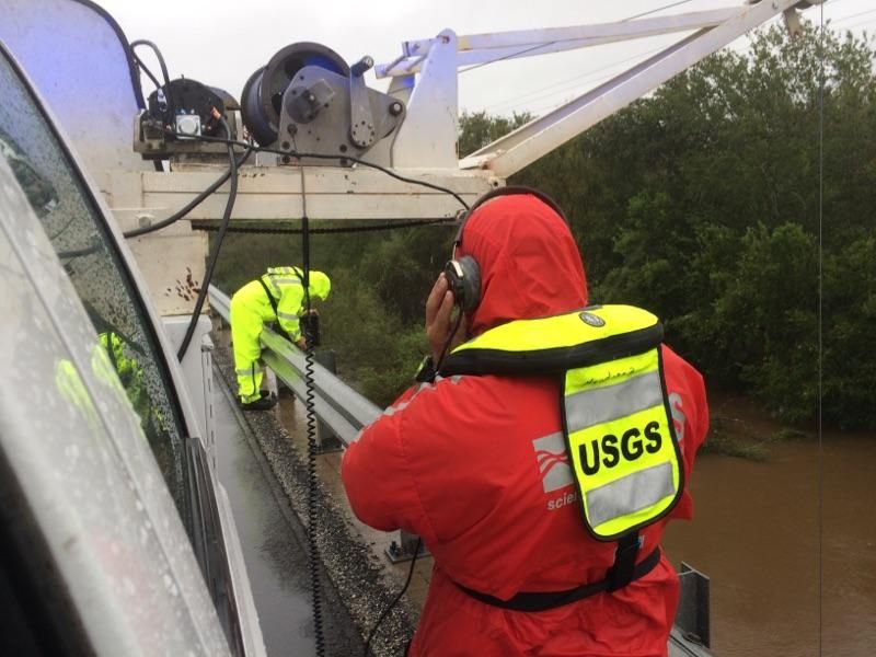
USGS scientists Vidal Mendoza and Brian Petri take flood measurements at
Fifteenmile Creek near Weser, Texas. The crew used a power measurement
technique, since acoustic measurements will not work due to a large amount of
sediment and vegetation in the floodwaters. Photo by Mark Schroeder, USGS.
Seventeen USGS field crews are measuring high flood flows and verifying streamgage operations on the Colorado, Brazos, San Jacinto and Trinity River basins. Preliminary data show record high flood levels were measured at 16 locations throughout the greater Houston area. Accessing specific locations has proved challenging due to road closures and many sites being flooded at levels too dangerous to measure at this time.
Today, crews will also start collecting the 16 USGS storm-tide sensors deployed prior to Harvey making landfall to measure and record storm surge impacts. This information will be used by the USGS and other federal, state and local agencies to develop or design better storm-tide models, and will contribute to more accurate flood forecasts.
As more rain is expected, the USGS will continue taking flood measurements that are critical for resource managers and emergency responders to help protect life and property. The USGS is coordinating efforts with the Army Corps of Engineers, the NWS and many other federal, state and local agencies.
New, innovative tools were released months prior to Harvey’s arrival that provide real-time streamflow, groundwater, lake levels, weather and flood predictions for Texas in one place. The Texas Water on The Go application is an easy way to for mobile users to access water information nearby. The USGS Texas Water Dashboard and accompanying Twitter feeds, @USGS_TexasFlood and @USGS_TexasRain, are available at your fingertips on your desktop, smartphone or other mobile device to quickly provide water and weather information for your area.
There are about 550 USGS-operated streamgages in Texas that measure water levels, streamflow and rainfall. When flooding occurs, USGS crews make numerous discharge measurements to verify the data USGS provides to federal, state and local agencies, as well as to the public.
For more than 125 years, the USGS has monitored flow in selected streams and rivers across the United States. The information is routinely used for water supply and management, monitoring floods and droughts, bridge and road design, determination of flood risk and for many recreational activities.
To learn more about USGS’ role providing science to decision makers before, during and after Hurricane Harvey, visit the USGS Hurricane Harvey page.
Source: USGS
Media
Taxonomy
- Groundwater
- Flood Management
- Measurement
- Flood management
- Groundwater Modeling
- Groundwater Mapping
- Flood prediction
- Flood Risk Management