Utilities Management System to 'See Underground' Wins Madrid Challenge 2017
Published on by Water Network Research, Official research team of The Water Network in Technology
The Horizon2020 project LARA, a software/hardware-based system, has won the Madrid Challenge of the European Satellite Navigation Competition (ESNC 2017). It enables utility companies to locate their key underground assets.
LARA is equipped with a high-precision, low-power, highly autonomous GNSS receiver module capable of achieving centimetre-level accuracy.
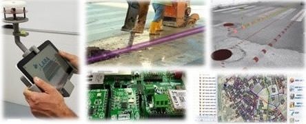
LARA combines different submodules – GNSS, Augmented Reality, 3D GIS and geodatabases – into an integrated navigation/positioning framework. By rendering complex 3D models of underground grids (water, sewage, gas, etc), the system guides utility field workers in their daily routines by essentially helping them 'see underground'.
It facilitates accurate maintenance operations on underground infrastructure without affecting adjacent underground grids, reduces overall maintenance costs and minimises economic and social implications of lengthy surface works.
The LARA system has been developed by a consortium of entities from Cyprus, Germany, Greece, Malaysia, Spain and the United Kingdom, and is coordinated by GeoImaging, a SME from Cyprus. With the achievement of the ESNC Madrid Challenge award, LARA will be able to rely on the potential to accelerate its commercialisation and market entrance.
Image: LARA project
Find out more about LARA project
Read full article: GIM International
Attached link
http://www.youtube.com/embed/Sp7CcB-KITUMedia
Taxonomy
- Technology
- GIS & Remote Sensing Technology
- GIS
- Leakage Detection
- Leakage
- Infrastructure
- Leakage Reduction
- Integrated Infrastructure
- Urban Water Infrastructure
- Infrastructure Management
- Multi-Sensor Pipelines
- GIS & Remote Sensing
- Pipes and Pipelines