The Colorado River: Designing Basin “2.0”
Published by Water Network Research, Official research team of The Water Network for Burnt Island Ventures in Case Studies
The Colorado River Basin was transformed into one of the most ambitious hydraulic engineering systems ever built, with a vast network of massive reservoirs, dams, canals, aqueducts, and pumping systems. The system allowed major cities to grow, vast agricultural regions to be irrigated, and industry to expand across some of the driest parts of North America. Today, the Colorado River Basin supplies water to roughly 40 million people and irrigates approximately 5.5 million acres of farmland.
The system worked well for decades. Reservoirs, groundwater systems, engineering, and periodic wet years buffered the basin against hydrologic imbalance. Lake Mead, Lake Powell, and basin aquifers functioned as giant multi-year “water batteries”, charging and discharging over time.
But the Colorado River Basin now operates under very different conditions than the system was originally designed for. The assumptions that shaped the twentieth-century Colorado River Basin no longer match the basin’s hydrology, variability, and current demands. The operating rules that have governed the basin since 2007 expire at the end of 2026 and present a rare opportunity to redesign the system.
Foundational Flaws
The 1922 Colorado River Compact divided the basin into Upper and Lower Basins and allocated 7.5 million acre-feet (MAF) of water annually to each. Additional legislation, interstate agreements, court rulings, and treaties (including the 1944 treaty allocating 1.5 MAF annually to Mexico) expanded the range of policies into the “Law of the River,” the legal framework that still governs the basin today.
The planners who designed the twentieth-century Colorado River system believed the river carried roughly 16.4 MAF annually on average, based largely on flow measurements during an unusually wet period in the historical record. Modern measurements, paleohydrology, and observed flows since 2000 show that the river’s long-term average flow is materially lower and more variable than assumed.
The 1922 negotiations also had a second problem. Thirty federally recognized tribes hold rights to Colorado River water, many of them senior to state allocations under the Winters Doctrine (federally reserved water rights). But tribes were not included in basin negotiations, and a significant share of tribal rights remain unquantified or undelivered today.
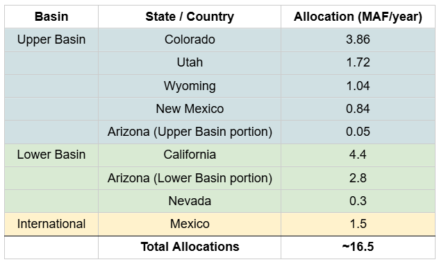
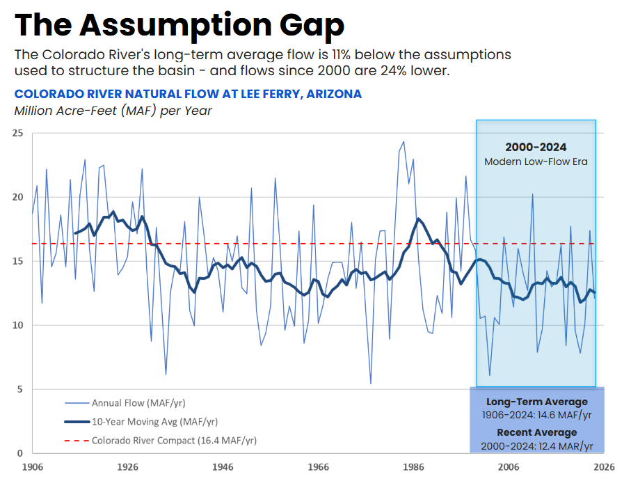
Caption: The Colorado River Compact was negotiated during an unusually wet period in the historical record. Modern measurements and paleohydrology show that the river’s long-term average flow has been lower than the assumptions used to structure the basin. Source: https://www.usbr.gov/lc/region/g4000/NaturalFlow/provisional.html
Tags
Category: Case Studies
- Basin Irrigation
- River Engineering
- River Basin management
- River Engineering
- Water Treatment Systems
- Colorado, United States
- Water sensitive design and planning