A 1.4-Billion-Pixel Map of the Gulf of Mexico Seafloor
Published on by Water Network Research, Official research team of The Water Network in Technology
The U.S. Bureau of Ocean Energy Management releases the highest-resolution bathymetry map of the region to date.
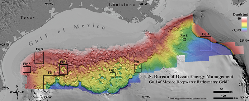
Fig. 1. Northern Gulf of Mexico deepwater bathymetry grid created from 3-D seismic surveys. The grid defines water depth with 1.4 billion 12 × 12 meter cells and is available in feet and meters. BOEM grid coverage is limited to the area defined by rainbow colors. Shaded relief is vertically exaggerated by a factor of 5. Locations of Figures 2–9 are annotated. Credit: BOEM
The geology of the Gulf of Mexico (GOM) is dynamic, driven not by plate tectonics but by the movement of subsurface bodies of salt. Salt deposits, a remnant of an ocean that existed some 200 million years ago, behave in a certain way when overlain by heavy sediments. They compact, deform, squeeze into cracks, and balloon into overlying material.
Salt tectonics sculpt the geologic strata and seafloor in the Gulf of Mexico like few other places on Earth.
Such salt tectonics continue to sculpt the geologic strata and seafloor in the GOM like few other places on Earth. Because of this salt tectonism and a steady supply of sediment delivered to the basin by rivers, the GOM’s seafloor is a terrain continually in flux. Bathymetry is ripe with active faults and escarpments, slump blocks and slides, canyons and channels, sediment waves, pockmarks and mud volcanoes, and other natural oil and gas seeps.
Now a new regional seafloor data set created by the U.S. Department of the Interior’s Bureau of Ocean Energy Management (BOEM) reveals that dynamic environment with stunning new clarity. The data include detailed seismic surveys originally shot by 15 different companies involved in the oil and gas industry.
BOEM gained permission to release the relevant proprietary data publicly in a freely downloadable aggregate map of the seafloor.
With a resolution as fine as 149 square meters per pixel, about equal to the areal footprint of an American single-family house, BOEM’s bathymetry map is at least 16 times higher in resolution than the map historically used for the northern GOM. Most of those house-sized pixels in the new map are 1, 2, and 3 kilometers deep under the water, and the product contains 1.4 billion of them, making this a gigapixel map.
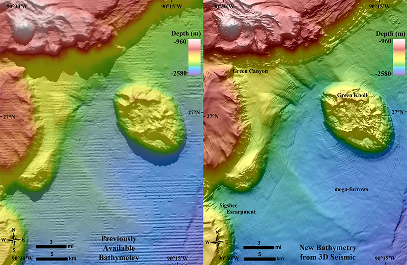
Megafurrows carved into the Sigsbee Escarpment and abyssal plain around Green Knoll,
central Gulf of Mexico.
Making an Aggregate Map
The geoscientists began with more than 200 individual seafloor maps created from 3-D surveys dating from the late 1980s to the 2010s. In the U.S. portion of the Gulf of Mexico, few areas are covered by only a single survey (some are covered by four or more), and the interpreters needed to compare one with another to determine which was made using the best data.
They created a mosaic of more than 100 of their highest-quality bathymetry maps, spanning water depths of 40 to 3379 meters and interpreted on seismic surveys originally shot by 15 different geophysical companies.
Geoscientists created a mosaic of more than 100 of their highest-quality bathymetry maps, interpreted on seismic surveys originally shot by 15 different geophysical companies.
Even though BOEM maintains copies of all the seismic data, the original companies retain legal ownership for a period of 25 years. Mergers and acquisitions through the years meant that instead of being required to ask 15 companies for permission to publish, BOEM needed to request it from only 7: CGG Services (U.S.), Inc.; ExxonMobil Corporation; Petroleum Geo-Services (PGS); Seitel, Inc.; Spectrum USA; TGS-NOPEC Geophysical Company; and WesternGeco, LLC.
Obtaining permission from these seven companies took months, much longer than anticipated, but eventually, BOEM received all necessary permissions and began the publication process. The new high-resolution grid is downloadable from the BOEM website.
The site also offers GIS layers that classify over 34,000 seafloor features such as pockmarks, channels, hard grounds, mud volcanoes, natural seeps, and others.
Read more: EOS
Media
Taxonomy
- GIS & Remote Sensing Technology
- Geology
- GIS
- Marine
- Oceanographic Survey
- Hydrogeologist
- GIS Spatial Analysis
- GIS & Remote Sensing
- Ocean engineering
1 Comment
-
We look forward to mapping out:
“ISHEAGU INDUSTRIAL BUSINESS PARK AND ENERGY FARM (IiPEF)”10+ MW POWER PROJECT