Prof. Eric Wood talks about global drought monitoring systems
Published by Water Network Research, Official research team of The Water Network in Academic
Prof. Eric Wood is famous for his work in hydrology, extending into meteorology and climate science. In the late 1980s, he led the development of a new area of research associated with determining the scaling behaviour of catchment hydrologic response. Wood also developed spatially distributed hydrologic modelling, which included the handling of energy, as well as moisture transfer dynamics at the land surface. Some of this work was facilitated by the land-atmosphere field campaigns of the 1980s. Beginning in the early 1990s, many of these concepts were included in the ‘variable infiltration capacity' macro-scale hydrology model, which is now used in a wide array of hydrologic prediction, water and energy balance, and ensemble forecasting applications. Our water network research team interviewed Prof. Wood on his research group's global drought monitoring system and its applications.
Q1. Can you give us an overview of using satellite data for global drought monitoring? Why is this the need of the hour?
Currently we use satellite data for two important variables: precipitation and vegetation. In theory precipitation data could be obtained by in-situ rain gauges or from rain radar as is done in Europe or the United States. Unfortunately most areas of the world are data-sparse - such information is unavailable (no gauges) or doesn't arrives in timely manner for monitoring applications - the data stays within the country.
Satellite measurements of precipitation are available every 3 hours from NASA's Global Precipitation Mission, and we use their data in our monitoring system. For vegetation, during drought conditions it is possible to see their response - vegetation tends to be less green and to lose leaves. This "signal" can be seen in certain visible light wave frequencies, which has led to the development of satellite-based vegetation indices (VI). Looking at the departures from normal conditions in the VI over large areas gives an indication that drought may or may not be occurring.
Q2. What are the major tools developed for the Global drought monitoring system by your research group?
Three tools: (1) data bases for meteorological information based on historical, current and future projections that can be used in themselves to look at drought risk related to temperature and precipitation (often referred to as meteorological drought);
(2) hydrological drought indices (such as our soil moisture drought index) based on our advanced hydrology models that provide estimates of soil moisture, evaporation and river flows that use the meteorological information as inputs; and
(3) weather and seasonal climate model information that allows us to provide forecasts of drought out to 6 months.
Q3. Who are the target audience / users of these tools developed ? Are they easy to comprehend by practitioners?
 In the United States we have transitioned our system to NOAA's Climate Prediction Center who uses the information in their "drought outlook" forum, where they provide monthly updates on drought to hundreds of users. These users include state and regional drought centers who themselves interact with stakeholders (water managers, farmers, utility companies) as well as large utility companies, etc.
In the developing world (say for our African Drought Monitor), our system has been installed in regional climate centers (e.g. AGRHYMET in Niamey, Niger or ICPAC in Nairobi, Kenya) who provide information to their own set of stakeholders. Other groups (e.g. the US AID supported Famine Early Warning System network FEWS Net) that works with many NGO groups in Africa. Our vision is to augment the way our information is delivered so that local people can access the information easily and directly.
Q4. How do you check the accuracy of these models ? Are the past drought patterns captured well?
In our analysis of our depiction of historical droughts, we capture past drought patterns very well. Similarly, when we compare our real-time monitoring of drought over the US with that estimates from the US Drought Monitor, which is based on many observers in the field, we also do extremely well. This gives us confident that our estimates in data sparse regions (like Africa) are also good as long as we work hard to obtain the best input data.
Q5. How challenging is it to set up observatories for collection of new data in developing countries where there are no weather monitoring stations?
There are many challenges here. Cost of the observatories is a big issue, so we've started to develop low-cost sensor observatories. Data collection and communication is a challenge so our observatories transmit the data over the cell phone network using SMS messaging, which is incredibly inexpensive in Africa. Finally securing the observatories is a challenge, so we try and partner with local communities where they see the importance of the information to their farming and will help protect the observatories.
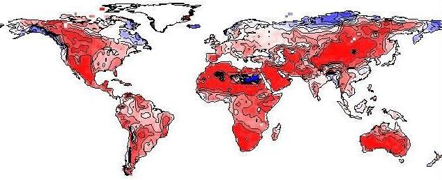
Q6. What is your prediction for the future ? Are the droughts expected to be severe, lasting for a longer time?
Our research shows that over the last 60 years drought hasn't increased but today with significant increases in world population (especially in Asia and Africa) the impacts from drought are larger and particularly food insecurity in the less developed regions of the world. Going forward, climate change (and more generally environmental change) projections suggest that drought will become more common, and probably lasting longer in semi-arid climate regions. As I showed in my talk.
Q7. What is your advice for water practitioners who are trying to implement new techniques for water conservation? Should they have an eye on these predictive models and plan accordingly?
Absolutely. Water conservation is probably the most cost effective way to plan for drought. Examples are improved irrigation systems, closed cooling towers in thermal electrical generation plants, and switching from coal fired generating plants to gas-turbine based generation. The development of more drought tolerant crops can also help, but these often come at a cost, and in the developing world the cost of these advanced seeds is beyond the budgets of local farmers.
Copyright: Water Network research, AquaSPE 2015
Read More Interviews from the 'In Conversation With' Series
by The Water Network
Tags
Category: Academic
- Research
- Drought
- Water Monitoring
- Hydrology