We are trying to map our existing water and sanitation (WASH) infrastructure facilities.
I am not a GIS expert but we are constantly suggested that we should use GIS and other tools for mapping this data. I am not sure how to do that. Is there any online simple user-friendly web-based tool which can enable geographical representation of data?
This mapping will help us formulate our priorities for the WASH project.
Have you ever worked with these tools? What is your feedback?
The Water Network research team has consolidated an answer to the above question. Further input from members is welcome and appreciated.
Here you can find a list of all GIS tools which are widely used for mapping the water and sanitation infrastructure.
As we know, unless collected data is easily accessible and presented in a structured, user-friendly way, it is practically useless. Geographic information system (GIS) integrates, stores, edits, analyzes, shares, and displays geographic information.
GIS relates different types of information by location as the key index variable.
Before mapping with GIS it is important to identify the objectives and target groups in order to get a clear focus of mapping. It is important to distinguish whether the goal is planning and monitoring or to empower communities.
Best Mapping Tools for WASH are:
QGIS
Google Fusion Tables
Water Pointer Mapper
FLOW
ArcGIS
Golden Software Surfer
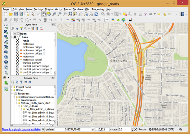
1. QGIS
QGIS, formally known as Quantum GIS, is a free, open-source cross-platform desktop GIS application. It is similar to other GIS and can be used to create maps with multiple layers using different map projections. The images can be georeferenced.
Advantages:
QGIS can be integrated with other open-source GIS packages.
It is possible to write plugins and add additional function options and more specialized tasks.
Geocoding (converting addresses to geographic coordinates) can be done with the Google Geocoding API.
A mobile QGIS version is currently being developed for Android.
QGIS Cloud is personal spatial data infrastructure (SDI) on the Internet. All the maps published on QGIS Cloud Free are available to anyone. Limiting accessibility can be achieved with QGIS Cloud Pro.
QGIS private Cloud is an excellent solution for planning and building an infrastructure. It provides security for your data and maps both on the intranet and internet and is easily installed on all platforms.
Fusion Tables is a web application for data visualization and sharing.
They can be used by anyone with a Google Account. Data from any spreadsheet (Excel or CSV) can be imported. It allows you to filter and summarize data easily and offers different options for data representation.
All data is saved and stored in Google Drive.
Advantages:
Simplicity and accessibility
Merging multiple tables to create a single one that contains all sets of data.
Combining public data with your own.
When any base data table is updated, the merged table will show the latest value
Data can be made public or private
Keeping track of the information source even after merging the data
Google Fusion Maps are rather unsophisticated, compared to other mapping tools, however they work well for designing and monitoring WASH systems.
3. Water Point Mapper
Water Point Mapper (WPM) is a free program for monitoring the distribution and status of water supplies.
It can import Excel data and plot it on a Google Earth satellite image or map.
The maps (KML files) can be opened in Google Earth which must be installed on your computer, and you either must have an internet connection, or that location must have been viewed previously in Google Earth so that it is in the computer’s cache memory.
WPM can be used for:
planning the water supply investments
measuring progress and performance
promoting increased investments in the sector
allocating resources to deliver basic services where they are most needed
Advantages:
Purpose-designed for mapping and analysis of waterpoint data
Automatic mapping
Input of administrative boundaries and automated calculation and mapping of district-level data
Area and point-based mapping
Works offline
Mobile Water Point Mapper is a mobile application that works online and has similar functions.
4. FLOW
Akvo FLOW (Field Level Operations Watch) is a system for the collection, management and analysis of geographically-referenced data.
It is mainly used to track the conditions of water points but is adequate for monitoring any kind of local infrastructure.
It is used on smartphones which are connected to an online database. Maps are immediately accessible to anyone who needs them.
Data is easily updated so information is always up-to-date.
Advantages:
Phone as a tool for gathering information
Available to anyone with internet connection
Easy, one-step solution follow-up data updates
Disadvantage:
It is a paid product
5. ArcGIS
ArcGIS by Esri is a free cloud-based service that offers real-time information, in-depth data analysis and shows location-related patterns.
It can make 2D and 3D maps and has a built-in map and scene viewer.
I use QGis www.qgis.org. Easy to use and the quality of the maps is awesome. If you need an easier one, use Golden Software Surfer 10, but this one is not free. Good luck.
Published
by Andres Alcolea Rodriguez, Head of Groundwater Division, TK Consult AG
mapping tools for water and sanitation infrastructure
Dear Mr. Rupasinghe,
World Bank-WSP-SA has developed mobile based monitoring, tracking and mapping system for toilets being constructed and used in villges in Rajasthan, India. You may contact Mr. Mathews Mullackal, State Coordinator, WSP, Rajasthan on his mobile no. +919928535654. Similarly, M/s Bule Frog Mobile Technologie (P) Ltd, Hyderabad has developed mobile based system for water. For this you may contact at Mr. Satya Vara Prasad on +919908940006 please.
If I understand your question..that you don't have any maps..and trying to map from the beginning...if so..then you have to get help from the workers,the technicians...any other as built drawings for all of the projects.........then you can use any version of GIS used in the ministries of the country....and why I'm saying used,,is that many times the companies of GIS give you specifications and tools for the software that doesn't work afterwards..so direct contracting with an expert is better of buying a useless version
Hello, for sanitation and piping you can use the software epanet for calculating losses due to pipping. On the other hand any Gis SW (ArcGis is the most common) and topocal are very reliable tools. And also you can use Google earth to adquire all coordenates you may require. Cheers!
so many tools use for water and sanitation in to the infrastructure.such as particle counter and others depend on required cleanliness of infrastructure.
An easy and simple solution would be to use 'my track' on the android platform to collect the information. It can take point information as well as in a track format with facilities of taking photographs. the data can be transferred on to Google earth as kml files and can be seen and stored (locally or on cloud)
Bhagya, I am not an expert in the area you are explaining. However, I do have a company that I have talked to that says they can easily handle data in their mapping software. It is cloud based so you do not load the software. Instead, you login and upload the data. I have not tried it yet, but they are anxious to work with people to help them learn the possibilities. If I can be of any help please let me know.
Published
by Cliff Love, Consulting Member at Carolina Eastern-Vail
I suggest you first use lithology+ Geomorphology intergrated map,,,,,,along with that use structure and lineament maps, ,,,,you may demarcate different aquifer boundaries,,,,,,and the same boundaries will may work for boundary for spatial mapping of ground water quality data. If you need information in detail ,,,you may contact me on paritosh219@gmail.com
Previously, preferred to have the coordinates from GPS,,that is important. If you are not GIS expert, maybe will be difficult to prepare map for this issues. I suggest to use Water Point Mapper
WaterPoint Mapper looks the best but check out this paper on Mapping and Managing Potable Water Infrastructure Assets,http://www.esri.com/news/arcnews/winter0809articles/mapping-and-managing.html
I strongly suggest to use Water Point Mapper, this is a free online tool developed by Wateraid. The Mapper is intended to offer a quick way to get up to speed with the process of Water Point Mapping and sector performance monitoring. It is aimed at water, sanitation, hygiene practitioners and local government staff working at district, sub-district and village levels. Its simple to use. http://www.waterpointmapper.org/ We used it last time for our project. while using if you can any problem, write me.